By Dan Potts
UTAH FISHING & OUTDOORS - December 31, 1991
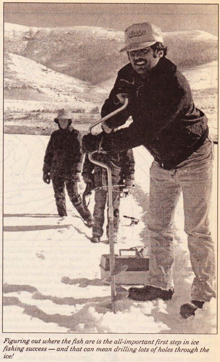
Like any other fishing situation, chance (luck) always plays a significant role in ice fishing success. When we are in the right place at the right time, using the correct lures or baits with successful presentations and techniques some of us call our success — luck! And, although luck will always play a large role in ice fishing success, there is an awful lot we can do to influence our success on any ice covered lake. Will how we cut ice fishing holes influence our success? of course it will! By using axes, Chisels and other impact cutting tools we will not only exhaust ourselves for but a few holes, but we will most likely end up wet from flying ice and water, or more likely from our own sweat. Sweat is the ice fisher’s enemy. While we might welcome the heat of exercise required to cut a hole we certainly regret the sweat that chills us to the bone later on as we cool down. A cold fisherman cannot concentrate on fishing. Also, the excess noise produced by these tools is likely to drive fish away, especially in shallower water, at least for a while. Many is the time I’ve caught fish immediately after angering a hole with a conventional ice auger. The reduced noise and increased efficiency of such angers are not as likely to spank fish.
Although fuel powered angers are more likely to spook fish, that consideration is usually out weighed by their efficiency in cutting many holes. With more holes to fish an angler is more likely to ‘pattern’ the fish and figure out just what is going on The obvious answer to having your cake and eating it too are the newer electric power augers that are not as noisy. However, these augers are limited to the amount of battery power you can drag around on the ice, unless the ice will support a 12 volt vehicle, or you employ a 12 volt generator. These options may be excessive or just not possible for some of our ice fishing opportunities here in Utah. Really, there is no need to throw a lot of money at ice fishing, unless you are a very serious ice fisherman. Keep it simple and light.
Basically, there are two types of ice angers: spiral and spoon. The spiral or ‘drill’ type anger is the most common type and is usually found on both power and hand-held models. The advantages of the spiral are that it helps to clean the ice shavings out of the hole as you cut and also aids in the downward pressure applied to the dual cutting blades. The spoon types are extremely light and efficient when kept professionally sharp, but are not ‘self cleaning‘, are harder to use in older and thicker ice, and more difficult to sharpen and maintain. So where does one cut holes on a lake? Fish are not randomly distributed on any lake. Available food resources, temperature, pH, oxygen, light, time of day and even the interactions with other fishes can all determine where the members and different sizes of any particular fish species may be distributed on a lake. Fisherman and even fisheries scientists are not yet able to put all of these variables together to determine how they all interact to predict fish location. However, a few of these factors can be valuable to fishermen if they are able to evaluate them. For example, knowing that actively feeding larger trout often cruise along a drop off where they are more able to ambush potential prey can be a valuable tool. Likewise, knowing that rainbow trout feed primarily during the daylight hours, especially earlier or later in the day can also be an aid to anglers. So, if an ice fisherman is after larger rainbow trout the angler can combine these two Valuable pieces of information and greatly increase fishing success.
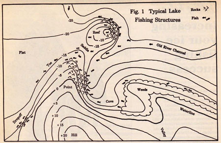
Like most fishermen, I have decided to employ proven, time-tested presentations in areas where fish are likely to be concentrated. For most fish species this means finding underwater features (structure) that either attract or funnel fish to the angler. I classify these structures into eight different categories: outside bends (points), inside bends (coves), toes, drop offs, rock piles (reefs), channels (old river beds), weed lines, and bottom transitions (see Fig. 1).
Outside bends or points are the obvious classic structures that typically concentrate the open water fishes like many trout species. inside bends funnel shoreline cruising species into relatively small areas. These two structures can often be identified by features extending up out of the lake. A ridge extending out into a lake as a point is likely to extend for some distance under water as an outside bend. Likewise, a valley entering a lake will probably result in an inside bend under water. So look for the best of these out«of»water features and you may have also found clues to the best fishing spots.
The other remaining structures are not typically identifiable from topography found outside the lake. To find these structures requires the use of a sonar, the drilling of more than a few holes, or a little luck. Toes are probably the easiest to find. Most of our Utah reservoirs have relatively steep sides and flat unproductive bottoms. Where the side meets the bottom is referred to as the toe, and this structure is usually easy to find and fish (see Fig. 3). Most toes also result in a bottom transition from hard to soft materials. This results in a better than random fishing spot.
However, where one chooses to fish a toe is of equal importance. The toe near the dam of a reservoir may be 100 feet deep and unfishable, whereas, the toe near an inlet may only be five feet deep. Your choice of a particular toe, and its depth may be of utmost importance to finding and catching desired fishes. Again, one‘s knowledge of fish biology can greatly influence fishing success.
Rock piles, like the productive one off Sweetwater Beach at Bear Lake, are often isolated and difficult to find. But, a reef in the middle of a vast desert of empty lake bottom is likely to be a veritable gold mine in fishing success. If one finds such a treasure it is desirable to mark the spot through triangulation,by taking compass bearings or alignments on landmarks, or by using a triangulation device like Zebco’s Spot Locator.
Drop offs, channels, weed bed edges and bottom transitions usually follow a straight or curved line and act as migrational routes or highways for fishes. They might provide cover enabling predators to ambush prey, or may concentrate food items associated with current, up-wellings or nutrients.
Bottom transitions from rock to mud, sand to gravel, etc., concentrate various fishes. These transitions can be easily found by using the ‘grey line' feature on many of the newer sonar (fish finder) units now available. The grey lines also aids in identifying bottom-hugging fishes (A discussion of on using fish finders on the ice will come in another article by this author).
The best fishing spots, however, are combinations of these various, previously mentioned, structures or more than one in close proximity. For example, a point ending in a drop off would be better than either element alone. Depending on whether one is after a more open water fish like rainbow trout or a usually bottom oriented fish like walleye, would determine whether one would fish just outside or just inside the drop off. Likewise, a rock pile partially encircled by an old river channel is likely to be a dynamite spot for just about everything (see Fig. 1). Fish cruising down the channel will tend to linger around the structure of the reef.
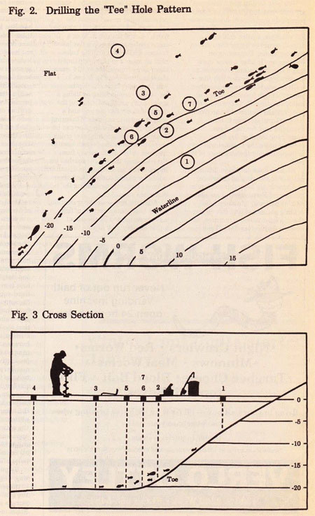
So, how does one begin drilling holes over a suspected structure, and how do we keep this work to a minimum? Fortunately, I am able to employ basically the same hole drilling pattern to find fish on any of the aforementioned structures, and even on feature less flats. I call the pattern the ‘Tee’, Basically, I start off by drilling a straight line of holes perpendicular to and across the structure. For example, if I plan to fish a toe, the transition from a steep shoreline slope to a flat lake bottom, I will start drilling holes near shore and continue cutting them away from shore until 1 cross the transition (see Fig. 2 and 3). I will then determine the depths below the various holes by using a sonar, or by simply measuring the depth with my fishing line and a weight (my lure is fine). Measuring the depth with a fishing line can be done by counting fishing reel crank revolutions from the bottom back to the hole or by backing away from the hole until the weight reaches its lip and then measuring the distance, either by pacing back to the hole or by more precisely measuring the distance.
After the hole over the transition, or the best concentrations of fish have been located by the use of sonar or simply by fishing the various holes. I then proceed to out new holes perpendicular to the most productive hole(s) in both directions (see Fig. 2). Then by examining these holes I again try to find the best hole(s) and I again continue to cut holes perpendicular to them. Before long, either a pattern appears (a line of productive holes), or at least I’ve narrowed down the possibilities.
On some structures a more precise location may require the drilling of holes between holes and even holes between them to locate the best fishing spot (see Fig. 2 and 3). This may result in holes only a foot or so apart. On other more subtle transitions or on flat and featureless lake bottoms, the spacing of holes may be many yards apart.
By looking more closely at the example (Figure 2) we can see the rational of approaching the problem of finding fish concentrations by the use of an efficient method. The water depth at the first hole is seven feet and no fish are seen or caught. The second hole is over 18 feet of water and fish are seen and caught but more and better producing holes are needed. The third hole yields 21 feet deep but few fish. The fourth hole is only slightly deeper than the third and produces even fewer fish. So, we know that the transition from the slope to the flat is between hole number two and three, and that the best fishing has been at number two. Hole number five, between two and three, is just more than 20 feet deep and just as productive as hole two. Hole number six is drilled perpendicular to holes live and two and yields similar depth and productivity. Number seven is also drilled perpendicular to five and two but on the other side and turns out to ultimately produce the most fish at the optimal depth of about 20 feet. apparently at the toe. In this scenario four fishermen could have all ended up with productive fishing holes after only having out seven.
By patterning the fish in such a way, anglers can track fish activity in perpendicular directions to follow the bite shallower or deeper, or along a structure. Also, as schooling fishes move through, anglers can anticipate school movement to increase fishing success This method often results in the cutting of many holes, but it also can result in a lot of fish. The basic philosophy of most successful ice fishermen is: if you are not catching fish - move! So, if you or your fishing party have a lot of holes to chose from, then moving around to find fish is easy. Once a successful terminal tackle and presentation have been found, moving around to find active fish is a far more productive and painless option than attempting to continuously change baits or lures.
So, how do we know where to begin looking for some of these harder to find structures? Fortunately an ever increasing availability of topographical maps intended for fishermen has led to opportunities for those anglers who have learned to interpret them Every year more new maps of common fishing lakes become available. Hats off to the Fish-N-Map Company for their contribution to an increased fishing success here in Utah. (Fish-N-Maps are available at most sporting goods stores. Although their maps are never detailed enough for some of us ‘serious’fishermen, and have errors that can lead to a lot of wasted time, they will certainly provide an aid to any angler, searching for new and better fishing spots.
For some reason, most anglers think that their summertime lake fishing haunts are not equally productive through the ice, This is probably a mistake. I find that many of my boat fishing spots have turned out to be very good ice fishing spots. I now spend a considerable amount of time searching for potentially good ice fishing spots while I’m boating around in open water with my fish finder. Just another reason to have a good sonar and the ability to interpret one.
Although different fish species do not necessarily relate to various structural elements in the same way, by reading up on their biology and familiarizing yourself with their preferences, you may be able to narrow down the available options and patterns for the fish you are after. By using the ice hole drilling ‘tee' approach mentioned herein the ice fisherman can key in on a good fishing location more quickly and avoid more of the bad luck in ice fishing.
Editor's Note: Dan Potts is a local fishing guide and outfitter servicing northern Utah with custom fishing trips for any species of Utah fish. He specializes in fish biology and ecology, spin fishing instruction and information about local fish resources. For information call Wasatch Adventures.