 By Lin Sorenson
(Published May, 2001, Utah Outdoors magazine)
When people think of river rafting, they often think of whitewater. Daily trips are run on river sections with frequent rapids in order to offer maximum thrills in the shortest number of miles. I did whitewater rafting trips for a few summers and enjoyed it, until my life began to mirror the boulder-dodging, boat-flipping, icewater-shocked action. Then I started looking for something different.
The San Juan River is a perfect place to escape the rapids of daily life and let the current take you through the spectacular scenery of southeastern Utah. The geology of the area rivals the best the Grand Canyon has to offer, and the wealth of prehistoric sites and beautiful hikes seem to be in endless supply — I could return again and again and never feel like I’d seen it all.
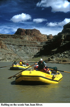
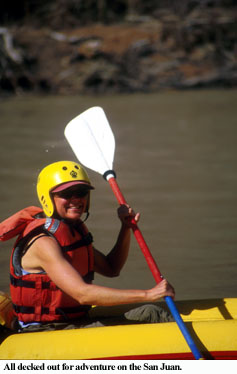
A few passengers and I joined a group of guides from O.A.R.S. (Outdoor Adventure River Specialists) for an early-season trip this spring. Their six-day San Juan trip begins at Sand Island, near Bluff, Utah, and covers 84 river miles, through almost 300 million years of geologic history, before reaching the take-out point at Clay Hills.
The ‘itinerary’
 A logical way to tell the story of a river trip is by marking it out in days and describing the events within each measured unit. But the time between Sand Island and Clay Hills didn’t feel like a progression of days or a linear set of experiences. Instead, it was a process of letting go and opening up — a single experience, with the passage of time marked by natural rhythm: the routine of loading and unloading boats; the sun dissipating the gray of early morning clouds to reveal a deep desert-blue sky; the evening light coloring water, air and rock. As Bruce Berger wrote about his two-week trip through Glen Canyon in 1962, just before the dam’s floodgates were closed, “Events remained sharp, but the days around them unraveled.”
Visitors will find the pace of this trip relaxed. No itinerary feels imposed. Dave Lyle, our trip leader, explains: “This is not a ‘checklist’ vacation, where you cram as many items into a short period of time as possible. It takes time to get a feel for the place you’re in — to fully experience it.”
The source of it all
The river starts in Colorado’s San Juan Mountains, where snowmelt flows south into New Mexico, then westward through Utah to Lake Powell. The rapids are not dangerous (Class I and II, with one Class III), but they’re rocky, which makes them interesting for guides trying to avoid perching or tearing a raft on the edge of a craggy boulder. The San Juan is known for its great current, with a vertical drop that ranges from 9 to 11.6 feet per mile (slowing to 7 in the Goosenecks area), compared to an average of 8 feet in the Grand Canyon. According to Lyle, San Juan River runners also enjoy the luxury of traveling through the last clean air reservoir left in the United States.
As many as 50,000 people float the river every year, which makes “Leave No Trace” practices critical to the health of the ecosystem. For example, even something as seemingly insignificant as dropping crumbs of food can affect the balance, as the ant population is controlled by the food supply. All waste is supposed to be carried out, and volunteer groups and clubs regularly float the river to clean up the banks and campsites. Cleanup is a huge task. Midway through our trip, we passed a group who dropped off almost 50 bags of trash at the Mexican Hat boat ramp.
Scenes from the river
The river cuts through a huge bump in the earth known as the Monument Upwarp, where the combination of the upward movement of the earth’s crust and the eroding effects of the river have exposed ancient layers of rock. The oldest layer, at river level, was formed approximately 300 million years ago.
This is Anasazi country, and the canyon has a wealth of rock art and ruins. Before we launch, we visit an amazing panel of petroglyphs carved into the desert varnish on a wall near the Sand Island boat ramp. If you take a pair of binoculars along on your trip, you can also see petroglyphs and a few ruins as you float the first few miles of the river.
Since we’re in a desert, we encounter the usual populations of ants, lizards, crows (or ravens) and occasionally, scorpions and snakes. The opportunistic crows circled above us each morning as we set off in the boats, to scour the campsite for leavings. But the river brings more life to the desert — beaver, assorted ducks, blue heron, canyon wrens and cliff swallows, and mule deer that hop up and down the steep inclines like long-legged rabbits. Canada geese stop by here on their migration path, following the river’s curves as they gracefully ride the air currents, their calls echoing in the narrow parts of the canyon. One still morning, a pair descended near our boats, positioning their webbed feet and skiing to a graceful stop. They floated alongside us for awhile, honking quietly back and forth before climbing ashore on a flat, sandy area that they carefully examined, like potential homeowners. Bighorn sheep also live here, and some areas along the river are closed to camping in order to accommodate them. We weren’t lucky enough to see any on our trip, in spite of the trained eye and persistence of Erik Thompson, an experienced guide and expert in the flora and fauna of the area.
We slowly descend to the canyon depths, cutting through Comb Ridge and winding our way through The Goosenecks, where the current slows and we find ourselves between towering 1,200-foot cliffs — layer upon layer of worn rock in soft coral and faded beige, like giant steps from the river to the mesa. The steep rubble between the layers is lightly covered by muted blue-green plant life faded to silver along the edges: agave and Spanish Dagger, yucca, cactus, sagebrush.
The canyon walls are marked by crooked shadows at all hours, angles of startling shade and light created by both sun and the waxing sliver of moon. When we camp deep in the winding canyons, our view is limited to the space between our last turn and the one upcoming, so the canyon looks closed at both ends. At night, it’s as if we’re in an oval bowl of rock, black except where the moonlight rests, the blue-black sky jagged and studded with stars. The sound of the river is always with us. We camp in rose-colored sand.
Near the end of the trip the canyon widens. Both the canyon and the river become shallow as we leave the upwarp. The cliffs are orange-red and skirted by talus slopes of the same color. The sound of the river is silenced as its current is overcome by the backwaters of Lake Powell. (The last 13 river miles – from Grand Gulch to the take-out point at Clay Hills – are filled with silt.) The guides row slowly through the shallow, still water studying the sandy water for signs of sand bars. We pass silt beaches filled with tall grasses of bleached gold.
Spending time on land
Although the main canyon is beautiful, there are plenty of reasons to get out of the boat and explore other areas. According to Dave Lyle, our trip leader, “75 percent of the good stuff is off the river.” In addition to numerous prehistoric sites, there are more recent “ruins” left by intrepid gold miners, would-be oil barons, and trading-post merchants who tried, unsuccessfully for the most part, to inhabit, profit from, or establish passable routes through this rugged area.
There are numerous well-preserved ruins and petroglyphs in the washes and canyons of the San Juan. Butler Wash and Chinle Wash contain much-visited — and photographed — rock art panels. One of the most accessible ruins is the River House cliff dwelling and granary, located in a small canyon between the two washes.
The Mule Ear diatreme, on the sharpest part of the Comb Ridge fault, is an interesting geologic formation that is visible from the river. It’s also accessible for hiking. It was formed by a volcanic pipe, originating at the earth’s mantle, that blew through the surface of the ridge about 25 – 30 million years ago. Over time, a mile or so of sedimentary rock eroded away, leaving the ear-shaped diatreme exposed.
At Comb Ridge you can also hike up San Juan Hill, where in 1897 Mormon settlers clawed their way across the ridge (at great expense to their animals and wagons) to reach Bluff before they ran out of supplies. The hike is moderate, and the view from the top is breathtaking.
A short distance below Ledge Rapid, you can climb to the ridge of the Raplee Anticline. It’s a strenuous hike, but if you make it to the top, you’re rewarded with a panoramic view of Monument Valley, Valley of the Gods and Mexican Hat.
Further down the river is Honaker Trail, in the deepest part of the canyon. In 1904, during one of the area’s gold rushes, the trail was built for pack animals to haul supplies to the mining site. However, the trail was too steep. According to several accounts, the only horse ever to attempt the descent fell off the narrow part known as The Horn, and supposedly his bones still lie exposed where he fell.
Slickhorn Canyon, possibly the most popular destination along the river, is a short hike and boulder scramble to a series of beautiful plunge pools fed by mossy waterfalls and seeps. It’s a popular place to swim, lounge and listen to the soothing sound of water trickling over stone. The site is in a layer of rock that was an ancient ocean bed, made of fossils that are about 300 million years old. It’s fun to pick through the flaking rock and look at the stony seashells.
Getting the full experience
Making a commitment to spend six days on a single river might sound unreasonable. After all, you can do Disneyland in less time. It is possible to shorten the trip by spending more time on the water, or by joining or leaving the trip partway through. (There’s a boat ramp at Mexican Hat for people wanting to make 3-day trips). But you should opt for a long trip if you can afford the time. According to Thompson, Lyle, and several of the other experienced guides on our trip, it takes three days for people to let go of their everyday concerns and immerse themselves in the experience and the landscape. Only after you allow time for your normal self-conscious barrier to melt away can you fully experience the place, unfiltered, on its own terms.
A visit to the artifact Hall of Fame
After unloading people, gear, and boats from the river and loading everything on the truck, we head out for the 5-hour drive back to Moab. But it seems our trip isn’t over yet. Just south of Blanding on Highway 191, we pull off the road and into a small parking lot in front of a log building – Huck’s Museum and Trading Post. Dave Bodner, area manager for O.A.R.S. says, “I drove by this place for years and had no idea what was inside. One day I decided to come in here and check it out.” The privately-owned museum contains an incredible collection of arrowheads, beads, jewelry, tools, bowls and pots. Hugh Acton (Huck) has thousands of artifacts, some of which he reconstructed himself. He also built, designed, and labeled his own displays. His collection includes donations from local citizens as well as artifacts from other U.S. sites, Old Mexico, Peru, and various locations around the world. His Hall of Fame is a collection of artifacts sent to him by people from an astonishing variety of locations. He carefully labels each one with the name of the donor and the location where the artifact was found.
If you go
Several area outfitters run trips on the San Juan River (see the Moab-area information box). To find a trip that meets your needs, visit the web sites listed. You can also call or e-mail to request a brochure. Ask about recommended times to visit, weather, water levels, etc. Check the itinerary to make sure you won’t be rushed. Also consider the time of year that best meets your interests. For example, May is a good month for hiking and wildflowers, June is high-water month, and July and August are good for swimming because the water temperature is warmer.
If you have a group with special interests or you want to set your own itinerary, you can charter trips with some outfitters. You identify your areas of interest (hiking, geology, etc.), trip length, etc. and they’ll find a guide to accommodate what you’re looking for.
Other calm water float trips are available on the Green and Colorado rivers (above the confluence). For example, you can float from Green River UT to Ruby Ranch (23 miles), Ruby Ranch to Mineral Bottom (45 miles), or Mineral Bottom to Spanish Bottom (56 miles). On the Colorado, you can float from the Moab Dock to Potash Dock (15 miles) or from Potash Dock to Spanish Bottom (49 miles). For more information, talk to a park ranger at the visitor center on 885 East Main, Green River, UT (801) 564-3526 or 805 North Main, Moab UT (801)259-8825 or (800) 635-6622.
If you are planning a self-guided trip, you will need to get a permit. Contact the Bureau of Land Management or the Park Service for more information. Answers to frequently-asked questions are available at www.blm.glv/utah/monticello/river.htm. The River Management Society also has information available on their site at www.river-management.org/digest. Keep in mind that the south bank of the San Juan River is Navajo Reservation land. Since this is private land, you are asked not to camp on that side of the river.
Bureau of Land Management
San Juan Resource Area
Post Office Box 7
Monticello, UT 84535
Telephone: 435/587-1544
Fax: 435/587-1518
Canyonlands National Park
2282 S. W. ResourceBlvd.
Moab, UT 84532
(801) 259-5277 (River District)
(801) 259-3911 (Headquarters)
Huck’s Museum is located at 1387 South Hwy 191, Blanding, Utah 84511. Phone for business hours (801) 678-2329 or (801) 678-2946.
Reading
Find a good river map or ask for reading suggestions from your outfitter. Here are two river maps that contain information about area geology, archaeology, history and biology:
A Naturalist’s San Juan River Guide, Stewart Aitchison, Pruitt Publishing Co., Boulder, Colo.
San Juan Canyons, A River Runner’s Guide, Don Baars and Gene Stevenson, Canon Publishers Ltd., Grand Junction, Colo.
The following readings can provide additional insight into the area:
Beyond the Hundredth Meridian: John Wesley Powell and the Second Opening of the West, by Wallace Stegner.
Natural History of the Colorado Plateau and the Great Basin, Kimball T. Harper (Editor), et al