


By Dave Webb (Published Feb 2006)
"Everywhere you look there are a million beautiful but weird shapes and colors," one of my companions said as we hiked toward The Wave, a unique rock formation in a place called the Coyote Buttes, on the Utah/Arizona border.
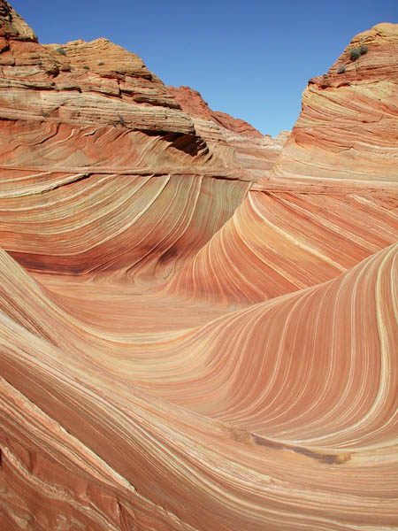
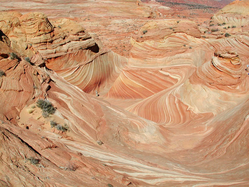
Swirled bands of color run through the Coyote Buttes sandstone, which has eroded into interesting shapes. The colors and shapes change with the light as the day progresses. Red, pink, yellow and green rock has been blended together to form castles, beehives, chutes and other structures. The scenery is breathtaking.
I hiked Coyote Buttes on Feb. 11 and had a wonderful time. Temperatures were crisp as we started hiking; by noon the air had warmed considerably and we shed our jackets. The air carried whiffs of spring.
The Wave, a multi-colored chute, is a key attraction in this area, but many other features are just as photogenic and make excellent destinations for day hikes. The Coyote Buttes are part of an area under special management by the BLM. Permits are needed to gain access and they must be reserved months in advance.
The Wave has become a popular icon, written up in guidebooks and shown in countless magazine spreads and website photo galleries. People touring the Southwest often include it as a must-see attraction on itineraries that include that include Grand Canyon, Zion, Monument Valley and other such famous destinations.
When I decided to go down there and see the area for myself, I wondered if it would live up to all the hype it has received. It actually exceeded my expectations. It's like a movie that you have to see on the big screen. Photos are nice but the rock is much more impressive when you get up close and personal. The surrounding area is gorgeous and the hike is easier and more enjoyable than I expected. It’s a great destination for family hikes. The only difficult part is getting permits. The BLM website describes the permitting process: www.blm.gov/az/asfo/paria/coyote_buttes/index.htm
The round trip distance to The Wave is about 6 miles, over a moderately difficult route. The hike itself is not that difficult but you do need route-finding skills because the trail fades on stretches that cross slickrock. When you obtain permits, the BLM sends you a map and also latitude/longitude coordinates so you can use a GPS to find your way. The BLM’s hiking instructions are good enough that most people should be able to find their way with little difficulty. I took my GPS but didn’t need it.
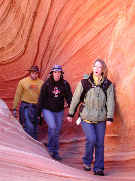
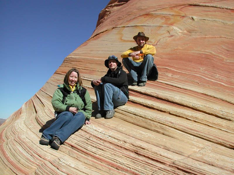
An interesting group of hikers shared The Wave with us during our visit. They included two photographers from Alaska, a California photographer who had lugged in a massive studio-size large format camera, and a family from Salt Lake City. Often, out of state and even out of country visitors far outnumber hikers from Utah or Arizona.
Hiking conditions should be excellent in our low-elevation deserts during the next few weeks. Winter has been dry and mild in southern Utah and most backroads are dry and driveable. Canyon potholes that are often filled with water during the spring are drying out early. Now is a great time to get out and hike.
Golden Webb provides this expressive description of The Wave and Coyote Buttes:
"Apollonius of Tyana said that God made the beauties of nature like a child playing in the sand. Perhaps no other place on earth illustrates the validity of that statement more profoundly than Coyote Buttes. It is a wondrous landscape formed completely of petrified sand and calcified dunes, layer upon layer frozen in time and sculpted by the elements into fantastic shapes that resemble the spires and domes a child might create on an ocean beach.
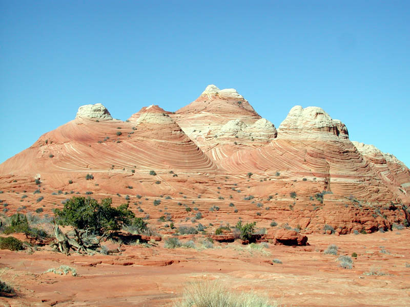
"Coyote Buttes is part of the Paria Plateau, a section of the Cockscomb that straddles the Utah-Arizona state line. Melted and carved by rain, buffed to a smooth and flowing finish by wind, it is a landscape that stimulates the imagination. Rock pyramids grow in organic clumps and resemble the barrows ancient peoples used to raise over the graves of kings. Swells of undulating slickrock mimic the rise, crest and fall of liquid waves. Stony troughs between the swells shelter motionless rain-water pools. Rounded domes bleed into each other to form fluted passageways, chambers and amphitheaters. Mineral deposits drench the slickrock in every hue of yellow, orange, red and violet. The rock is veined and banded, a thousand separate formation seams distinguishing a thousand separate lenses of sandstone.
"The crenelated sandstone is so exquisite, so delicate, that the BLM has imposed a limit on the number of Vibram soles allowed to tread it. The limit is about 40, assuming all 20 people have only two feet. That's right, only 20 people per day are allowed into this mysterious desert terrain.
"Coyote Buttes is managed as two units, Coyote Buttes North and Coyote Buttes South. On December 24, 1997, each unit was mandated with a visitor use limit of 10 people per day. This is up from the 4 people per day limit established in 1986. Coyote Buttes North is the more popular of the two units. It contains the Wave, a wondrously sculpted sandstone formation that every professional nature photographer worth his salt is required by conventional wisdom to have in his portfolio. The Wave lies on the northwestern tip of a prominence called Top Rock, along the eastern edge of Sand Cove. This formation is so sought after that reservations for the peak seasons of March-May and September-November must be made months in advance. Much easier to access is the south section, which is just as beautiful but can only be reached by hiking after negotiating a sandy 4WD road.
"When you see Coyote Buttes in the flesh, with your own eyes, all the rules and regulations, visitor use limits and fees, crystallize in your mind and start to make sense. This is a landscape that truly must be preserved in situ, an incredible jewel that some people consider to be the most beautiful place on earth."
"The strict regulations are absolutely necessary," said Paula Swenski, an intern and graduate student from NAU who helped the Paria ranger patrol the wilderness area and enforce the rules. I met her at the Wire Pass Trailhead, where she was fastidiously checking each parked vehicle to make sure it was displaying its yellow parking tag. "We tend to get a lot of gate-crashers, people who show up without a permit but are hell-bent on seeing The Wave. The culprits include a lot of Europeans with vague maps who've come half-way around the world looking for the 'Coh-oh-te Boots,' but there are a lot of guilty Americans too, people who understand the rules but consciously choose to disregard them. The resource is so fragile that people have to be more conscientious if they want to continue to enjoy it in the future."
Copyright Dave Webb, 2006