By Dave Webb
(Editor's note: A massive flash flood in late 2003 deposited a huge logjam at the bottom of the Black Hole, making it hazardous. Now some websites report that most logs have been washed downstream and the route can be navigated successfully. We visited on 10-10-09 and found the route is much more difficult than it was before the logjam. It is still an enjoyable strenuous hike suitable for strong, experienced canyoneers.
Your Lake Powell vacation is starting to drag. You've caught a dozen different kinds of fish, skied the hundred miles from Waheap to Hite and you've explored each of the lake's countless side canyons. What else is there to do at Powell?
Well, there are a few good hikes in the area and fall is a great time to hit the trails in Utah's desert country.
There's a fun canyon hike that begins just up the road from Hite Marine. It's called "The Black Hole of White Canyon" and it's one of the best hikes in the area. No, change that. It's one of the best hikes in the world. It's the most fun slot canyon I've ever hiked - and I love slot canyons.
Please don't misunderstand when I use the word "fun." It's a fun hike which is both physically demanding and mentally challenging.
It's also a hike which carries an element of danger. Horrific flash floods rage through the canyon when it rains anywhere in the upper drainage. Luckily, it only rains a few times a year. Still, people occasionally die in this canyon - usually because they didn't keep a wary eye on the weather.
 White Canyon roughly parallels Highway 95, running from Natural Bridges National Monument down into Lake Powell. From most places along the highway you have no clue there is a rugged and interesting canyon nearby. It looks like the country is fairly flat - that you could wander off into the desert with few obstacles to inhibit travel.
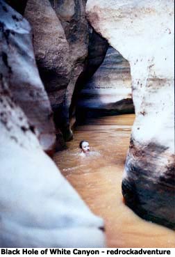
The highway crosses the canyon a few miles south of Lake Powell, giving travelers a glimpse of the splendor of White Canyon. The terrain is fairly level and not particularly remarkable. Then you come to a bridge that spans a gorge - just a couple dozen yards wide and perhaps 250 feet deep. With sheer, vertical walls of solid sandstone. It's the kind of canyon that beckons to hikers, that draws them down to explore its twists and shadows and crevices. That pulls them onward, deep and deeper into its bowels - into its "Black Hole."
It's a fun canyon that offers several wonderful hikes: the loop at Natural Bridges, "The Cheesebox" with its deep pools and difficult obstacles, Fry Canyon with its Anasazi ruins. . .
Into The Black Hole
There are only a few places where you can descend the vertical walls and gain entrance into the lower part of White Canyon. It takes some moderate scrambling to get into the canyon, and then a bit more to get out. And that's the easy part. You hike down-canyon, climbing over boulders, sliding down sandstone cliffs and wading through deep pot holes filled with chocolate-colored water. That's the other easy part. Then you come to the Black Hole. . .
As you approach the top of the Black Hole you notice the canyons is narrowing. Looking ahead it seems that the walls merge and you wonder, "Can I get through there?" You walk cautiously forward and discover the canyon floor drops about 30 feet. You have to scramble and slide down a series of cliffs and at the bottom there is water - and you can't tell how deep it is. You try to mentally map your route: around that outcropping, between those protruding cliffs, down into that shadowy area and then. . . who knows what lurks beyond the far shadows.
 When I stood there, trying to see over the dark water and through the dark cliffs, I thought to myself, "You gotta be kidding. There's no way I can make it through that maze of rock and water."
The one thing I knew for sure is that I couldn't go back. We had slid down two dry falls into water deep enough that I couldn't touch bottom. It would be all but impossible to swim to the base of those falls and then find a handhold to pull oneself up.
So, having faith in the reports of hikers who had lived to tell of the adventure, I held my nose and slid into the water.
It was over my head, as expected. But I found I could swim forward easily - that the canyon walls closed above me but at water level it was possible to glide forward into the dark crevice. We swam forward - 50 yards, 100 yards. Then we came to a spot were the walls did tighten around us, and at the same time the canyon made a 90 degree turn.
This is the heart of the Black Hole. This is the spot where unprepared hikers have trouble. My shoulders brushed both walls as I swam through the constriction. I had a day pack strapped to my back, and made it with no difficulty. It would have been another story if I had tried to get a frame pack through.
Past the turn we swam another 50 yards and then touched bottom. That's a long swim, in cold water.
It felt good to get feet back on solid ground. But then a chill hit us. It was a hot summer day (early August), but we were thoroughly chilled as we climbing out of that cold water in that dark canyon - which is so deep and narrow that the sun's rays never reach the bottom in some places.
We had anticipated the cold and had dry shirts in plastic bags in the daypack.
But we didn't have long to get comfortable. There were still long potholes to swim and many rocks to scramble over before we reached our exit point and won the right to fight our way up the canyon wall to my truck.
The hike's only about five miles - from trailhead to the car park at the bottom. But it's a long, challenging, exciting five miles. This is a great hike which I highly recommend, but only for seasoned canyon hikers who are physically strong and emotionally tough. It would be easy to panic at the top of the Black Hole, were you can't see a way to go forward and you know it's too late to turn back.
Hike Details
Attraction: A challenging hike through a scenic slot canyon, with several long stretches of water where you have to swim.
Location: Just south of Hite Marina on Lake Powell, along Highway 95.
Difficulty: This is a difficult hike. Physical size and strength are important. Recommended for experienced hikers over age 16.
Length: It's only about five miles through the canyon. Add a couple more miles if you have to road-walk back to your vehicle.
Time needed: We completed the hike in five-and-a-half hours, keeping a fairly brisk pace.
Time of day: It's definitely best to start in the cool of the morning. The big danger is flash flooding from thunderstorms, and they are more likely during the afternoon.
Season: Hot days from June into October. This is a warm-weather hike. It may be hot as you make your way into and out of the canyon, but it will be cooler when hiking in the bottom. The hike requires wading and swimming long pot holes, and the water in the holes is cold. Hypothermia is a danger.
Clothing: Its necessary to wear boots or hiking shoes which provide support when wet. You need a stout sole while climbing over rocks. Even when swimming you will bump and scrape your feet against rocks. You need clothing which will allow you to swim freely (you'll need to swim about 200 yards in a couple places). It's important to have a dry shirt which you can put on after completing the swim through the frigid water. Some people carry an extra shirt, others remove their shirt when they start to encounter deep pools. It's sometimes difficult to anticipate how deep a pool will be until you slide into it - and then you are often wet up to your hat.
Special equipment: Everything will get wet unless you carry it in a waterproof bag. Some kind of small backpack is recommended because you need your hands free as you scramble over obstacles. A small tube could be used to float a small pack through the Black Hole. You will not be able to get a frame pack or a car-tire size tube through the 90-degree turn in the middle of the Black Hole.
We devised a method that worked well. We put our stuff into plastic bags, then into a day pack. We straped a life jacket to the underside of the daypack - so the pack was on top, then the lifejacket, when I wore the pack. When the water became deep the pack would float up behind me, staying mostly out of the water. I could hike and swim almost normally while wearing the pack. The life jacket provided enough buoyancy that it could have supported my weight, if needed.
Map: The Copper Point 7.5' topographic map shows the entire hike. Any good highway map will show the general location.
Water: Carry some. Water does not flow through White Canyon unless it rains - and then you had better not be in the canyon. The pot holes in the bottom get flushed regularly but the water there is sandy, brown and unappealing.
Recommended loop: Park at mile marker 57 along Highway 95. From the parking area walk due north for about 200 yards, to the top of a small side canyon where you can descend rapidly to the bottom of a larger tributary-canyon which will take you down into White Canyon. There has been a sign marking the point where you can descend the side canyon - we found it on the ground several yards away from its post. Several trails lead away from the parking area, and some probe the canyon in other spots. The main trail down the side canyon is well beaten and easily recognizable.
When you get to the bottom just walk down-canyon and through the Black Hole. Below the Black Hole you will find a few spots where you have to swim, then the canyon widens and you stay on dry ground. At that point watch for a side canyon coming in from the south (the left as you walk down-canyon). It's the only side canyon in that area which comes in from the south, so you can't miss it. As you pass the side canyon watch for an obvious trail and cairn markers showing the way up the canyon wall. A minor trail goes up the bottom of that side canyon but it's not the best route. It requires considerable rock climbing to get out that way.
When you get on top just follow the trail to the parking area at mile marker 55.
GPS: (The unit will not work in the deep, narrow canyon, but is valuable to help locate the starting point and help you find your vehicle after you exit the canyon.) Coordinates given below are in UTM, which corresponds with the grid on 7.5' topo maps.
Parking area at mile marker 57: 12 N. 0561238 E. 4183669 N.
Entrance point on side canyon: 12 N. 0561370 E. 4183868 N.
Out of canyon above exit point: 12 N. 0558301E. 4185481 N.
Parking area at mile marker 55: 12 N. 0558336 E. 4185100 N.
Copyright Dave Webb, 2006