|
|
 By
Lin Sorenson
(Published May, 2002, Utah Outdoors magazine)
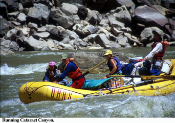
When people think about Cataract Canyon, awe-inspiring rapids come immediately to mind. The canyon is legendary, thanks to vivid stories of raging torrents and capsized boats written by the explorers who first navigated the waters. Some, like John Wesley Powell, left detailed journals. Others merely scratched inscriptions on the canyon rock to mark the location of an event—usually a catastrophe like the loss of a boat.
Cataract Canyon packs 25 rapids into 37 river miles, and when Lake Powell is low, you get two bonus rapids that are normally covered by the lake. This is a low-water year; we get 27.
 The
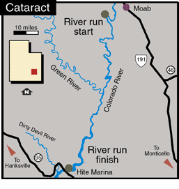
trip begins a few miles from Moab, where we launch into the calm waters of Meander
Canyon. We’ll have two days on the Colorado before we hit the Confluence, where
the Green and Colorado meet before plunging into narrow Cataract and merging
with the backwaters of Lake Powell. If you’re in an oar boat, this 100-plus
mile trip takes six days. In a motorboat, you can do it in as few as two days.
My trip, with Outdoor Adventure River Specialists (O.A.R.S.), is four days long—a
nice compromise that allows time for some hiking and relaxing on shore.
The four-day trips are popular because they fit more easily into the typical one-week vacation slot. And you can’t beat the trip for variety—the combination of calm water winding through scenic Canyonlands, the excitement of whitewater, and some amazing hikes.
We load two 22-foot J-Rig boats (motorized pontoons) and push off, with guides Rob Ho and Chris Dean manning the boats. We strap the boats together to make a floating island as we begin our trip through Meander Canyon. The guides help ease everyone through the transition of leaving the world behind. Rob handles introductions and keeps everyone entertained with stories, and Chris points out sites of geological and historical interest along the way.
We make a couple of quick stops our first day out. Not far from the river are petrified logs believed to be ancient palm trees. Palm trees in the desert? It’s still a mystery whether they grew here or were carried by water. Only time will tell; if they grew here, more will be exposed as the canyon erodes. We also take a quick hike near Lathrop Canyon to see pictographs, and then, like a herd of overheated lemmings we rush down the trail and plunge in the river to cool off.
On our second day, we brave the morning heat to hike a shortcut—a narrow wall of rock that keeps the river from doubling back on itself. We climb a steep half mile for a great panoramic view, and then pick our way down the other side while the boat, far below, follows the four-mile loop of the river we bypassed.
In the early afternoon we pass the confluence, ride our first rapid and call it a day. We’d been looking forward to seeing the Doll House, but in the 105-degree heat of early afternoon, a hike is not our immediate priority. We hide from the sun and make occasional runs across the hot sand to cool off in the river. Sometime after 3 p.m., we decide to go for it. Wearing hats and long-sleeved shirts, we douse ourselves in the river to stay cool and make our way, dripping, along Spanish Bottom to the trailhead. The trail is short, but steep—1,200 feet of steep switchbacks in less than a mile.
At the top is a mesa inhabited by huge, odd-shaped pinnacles scattered oddly around like, well, deserted dolls in a giant dollhouse. They’re ancient, impassive, mute. We are transient, incidental. Instead of walking the five-mile loop around the Doll House, we choose instead to find a shady outpost and enjoy the view of Canyonlands. We’re in The Maze District, and we can see the Needles District and Island in the Sky, as well as the San Juan, Abajo and LaSal mountains.
That night we fall asleep to the sound of whitewater. Below us, Rapids 2-27 await.
Past the confluence, the gradient of the river changes from one foot per mile to between eight and 30 feet per mile. After getting safety instructions from our guides, we push off and prepare to meet the rapids.
We spend the rest of the day climbing out of the boat to study rapids, and then climbing back in and running them. This is exciting because we get to see what we’re getting into before we hit it. Mile Long Rapid is actually five, closely-spaced rapids (including the aptly-named Capsize Rapid) that merge in high water to form a long stretch of whitewater. Near the end is Big Drop, a series of three rapids, where the river drops 30 feet in less than a mile.
According to John Wesley Powell’s report on July 24, 1869, “Large rocks have fallen from the walls—great angular blocks, which have rolled down the talus and are strewn along the channel. We make three portages in succession. Among these rocks, in chutes, whirlpools, and great waves, with rushing breakers and foam, the water finds its way. We stop for the night only three fourths of a mile below the last camp. A very hard day’s work has been done.”
At Rapid 25 we officially enter Lake Powell. We run our two bonus rapids and then motor down the lake and set up camp. It’s amazing to contemplate the experiences the early explorers must have had in this canyon. Before Glen Canyon Dam was built there were 52 rapids to be navigated; half of them are now buried under 90 feet of silt. There’s a lot of canyon beneath us, and a lot of history.
Before you book a trip, do your homework. Ask outfitters about their client-to-guide ratio and the level of experience of their guides. (This can range from college students filling a summer job to seasoned guides who know the canyon well.) An overwhelmed crew has no time to worry about whether you’re getting the most out of your experience. “Our guides work three to four years before we put them on Cat trips,” says Jason Taylor, who works in the O.A.R.S office in Moab. “We’re concerned about the complete experience. It’s important to us that each person has a good time and feels taken care of."
You must go with an authorized guide or get your own permit. For a list of outfitters and private permit info, call the Canyonlands National Park Service (435) 259-7164 or the visitor’s center (435) 259-8825; or visit the web site at www.nps.gov/cany.
River maps are a good source of information about the river as well as the geology and wildlife of the area. Look for “A River Runner’s Guide to Cataract Canyon” and “Approaches” by Don Baars. “Belknap’s Revised Canyonlands River Guide” by Bill and Buzz Belknap and Loie Belknap Evans covers six rivers and Lake Powell as well as sections on area geology and history.
Lastly, you can fly back to Moab from Lake Powell’s Hite Marina instead of using the outfitter shuttle. It’s a great way to cap off the trip, because you fly over the same stretch of river you floated through. You get a whole different perspective of where you’ve just been, plus a great tour of Canyonlands from above. Call Arrow West Aviation at (435) 259-7421 for information.