|
|
|
|
Rebuilding the Provo River
| By Sam Webb For a number of years now I have been upset and saddened because one by one our streams have been lost as excellent fisheries as their riparian systems have been destroyed or because the property owners along the stream denied access. The riparian system along the Sevier River (and both the East and West Forks) have been subjected to extreme overgrazing and large sections of the stream have been destroyed. The Fremont River has suffered a similar fate. The Weber River, in the name of flood control, has been channelized and large sections have been closed to fishing. For years the upper Strawberry River was subjected to intense over grazing and the stream was almost lost as a trout fishery. I could go on and on, and I am sure you can think of several streams that have been severely impacted by poor land management practices and/or closed to fishing by land owners. I cheered when the upper Strawberry River restoration began and have watched with keen interest as that stream system has began to heal. I have excitedly watched as small restoration projects on the East Fork of the Sevier River, Corn Creek and Asay Creek have been undertaken. But, I also understood that stream restoration projects cost an unbelievable amount of money and take a lot of time and commitment from land owners, water companies and from the general public. I also understood that raising enough money to make serious improvements to our stream systems was probably not going to happen. Then an interesting thing happened. When Congress funded the final phase of the Central Utah Project millions of dollars were included for mitigating the damage done by federal water projects in Utah. Now, I don't want to sound like a skeptic, but I have seen the Federal Government at work enough times to wonder if all this mitigation that was supposed to be done ever would be done. I watched with interest as the Utah Reclamation Mitigation and Conservation Commission was formed. I got excited when the Commission proposed that the Provo River riparian system between the Jordanelle Dam and Deer Creek Reservoir be restored, that access to the river system be obtained and that the corridor be opened to anglers and anyone else that wants to walk the riverbank. For the first time in my life I felt like there was an opportunity to undo a hundred years of mismanagement and to actually rebuild a river system. You see, they aren't making any more rivers and that makes it vitally important that we take care of the ones we have. |
|
Of course, as with any government project, there are lots and lots of steps between saying you want to do something and actually doing it. An Environmental Impact Statement had to be prepared, landowners had to be contacted and convinced that they ought to participate in the project, Congress had to actually allocate the money and the State of Utah had to be convinced that the project should be done.
Well, the Final Environmental Impact Statement has been prepared. Alternatives have been proposed and one has been accepted. The Feds have actually allocated just over 10 million dollars and promised another 14 million shortly.
Hang on to your seat 'cause this one is actually going to happen and I am excited.
Why restore the Provo?
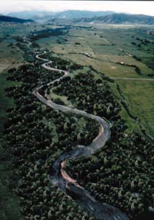
So, why does this section of the Provo River need to be restored? Beginning back in the 1940s and 50s the project area was extensively channelized and diked. Prior to this time when the river overflowed its banks large tracts of bottom lands would be flooded and the river would meander freely across its floodplain.
Again during high water years of the early 1980�s the dikes were reinforced and the channel was cleared so as much water as possible could be moved through the system.
Of course all this straightening and diking completely destroyed the riparian system and the number of birds, fish, amphibians and other animals the system could support dropped drastically.
The restoration project will undo all of this damage and repair the riparian system.
Who is in charge of the project?
The Utah Reclamation Mitigation and Conservation Commission is in charge. The commissioners are:
Don A. Christiansen, Chairman; Jody Williams, Vice Chair; Bob Nelson; Bob Valentine; and Wayne Owens.
The people that will actually get the work done are:
Mike Weland, Executive Director; Mark A. Holden, Projects Manager; Chad Gourley, Project Coordinator; and Diane Simmons, Public Infor-mation Officer.
How much will it cost?
Estimates are that it will cost 24 million dollars.
How long will it take to complete the project?
Approximately six years.
What does the DWR think about the project and what will be their involvement?
I talked to Charlie Thompson, DWR Regional Fisheries Manager, in charge of the Provo River. Charlie said, "This is the greatest opportunity for fish and wildlife I have ever seen. We don't get many opportunities to restore a 10 mile section of river, especially one so close to so many people."
Charlie said that the DWR will not be in charge of rebuilding the river system but will have input.
The DWR will be in charge of the fishery, the planting and harvest of fish, fishing regulations, giving citations to those breaking the rules, etc. just like on any other river in the state.
Will the fishing improve?
After the entire system has been restored Charlie said the estimates show that the biomass of fish will increase by about 25,000 pounds per year. If you figure three fish to a pound, that's about 75,000 additional fish over the 10 mile stretch of river, or over 7,500 fish per mile!
How will the river system change?
The river will change dramatically. Currently the river bed is basically a flat-bottomed bowl shaped canal. The plan calls for reconstruction and realignment of most of the existing river channel and floodplain system into a meandering riffle-pool sequence where there are alternating shallow and fast and deeper and slower sections of water.
By restoring the meanders approximately two miles will be added to the length of the river between the dams.
The existing levees will be removed. However, 100-year flood protection will still be provided by the expanded floodplain and new setback levees. The new floodplain would be subject to flooding once every two years and once every 5 years with velocities capable of scouring surface soils. These conditions are necessary for natural regeneration of cottonwood trees and other riparian vegetation.
The river will be allowed to flood onto the expanded floodplain and to alter its course. The river channel may widen or move across the floodplain in response to natural forces similarly to how it functioned before channelization. The entire floodplain will be revegetated with indigenous plants.
What can I do to help?
However, once the restoration is underway help will be needed to plant vegetation along the corridor and to clean up newly restored areas. After the project is completed it is hoped that various fishing or outdoor groups will adopt the river and work to keep the corridor free of trash and to keep the trail system in good repair.
Will there be improved access?
Yes! While a low level of development is planned (the corridor will be restored to as natural a state as possible) there will be seven parking areas built (parking for about 100 vehicles) with restrooms and trash pickup. A low impact trail system will also be developed.
There has been some discussion about charging a fee to park along the river to bring in money to maintain and repair the parking areas and the restrooms as well as the trail system. Before a fee is charged, anglers will be asked for their thoughts on the idea.
What about handicapped access?
Handicapped access will be provided to short sections of the river along paved trails and boardwalks. This will allow handicapped anglers to fish and enjoy the area.
Will the fishing regulations change?
Currently there are no plans to change the fishing regulations. However if the fishing pressure increases beyond the rivers ability to handle then changes may be needed. Charlie said the river will be managed with a high priority placed on the resource and the environment. There will be limited access points and the trail system will be built to minimize riverbank destruction.
If more people want to fish the river than the river can handle, limits may be placed on the number of fishers on the river at one time. Charlie wants to balance a high quality fishing experience with as many people as possible: "We don't want to exclude anyone if that's possible. We want everyone to feel like it is their river." Charlie concluded that, "It's too early to know if changes will be needed or not. We'll just have to wait and see."
What about major floods?
Won't the restored river system be destroyed if we get another series of wet years? No, major floods will be controlled by Jordanelle Reservoir and the river below the dam won't see floods like there used to be. The water flow from the dam will be regulated so, although the river will be allowed to overflow its banks, all the water will be contained within the floodplain created for the river system.
If the riparian system is to remain healthy, the river must be allowed to flood but all floods will be controlled by the release of water from the dam.
Minimum flows
An important part of the restoration project is that minimum flows of 125 cubic feet per second be maintained in the river at all times. This will ensure a healthy fish population as well as benefit the entire riparian system.
Fish migration
The river will be reconstructed so fish can migrate the entire length of the stream between the dams. Now there are several diversion dams that block the migration of fish. These dams will be rebuilt so fish can either move up or around them. When will the reconstruction actually begin?
This fall, and I for one, can't wait!
Special thanks to Mark Holden, Diane Simmons and Charlie Thompson for providing me with the information found in this report!