A Swell Sampler — The San Rafael Knob
By Dave Webb
 The San Rafael Swell in southeastern Utah is an amazing hunk of real estate that well deserves its reputation as a premier hiking area. It offers a range of experiences ranging from family-friendly to technical and extremely difficult. The common denominator is amazing scenery — the canyons and slickrock formations here rival any national park for sheer beauty. Fall is the perfect time to explore this area.
When you first try a new restaurant you may do well to order a combination platter, and enjoy a sample of some of the best the establishment has to offer. I recommend a similar approach to the San Rafael Swell. The hike described here provides a sample of the Swell's best: a hike up Devils Canyon, through scenic narrows, scrambling over boulders and around dry water falls, and then a taste of rock climbing to the top of the steep monolithic San Rafael Knob – the highest point on the Swell.
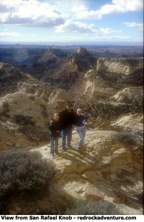
From the top of the Knob you can see forever, almost.
In this article I don’t attempt to give detailed hiking instructions. I just want to give an overview of the area and whet your appetite for adventure here. For specific instructions I recommend the guidebook, Canyoneering, The San Ralael Swell, by Steve Allen. It is excellent. It gives an overview of the area and describes dozens of other hikes.
The hike to the Knob covers about 10 miles, round trip. It's a challenging hike for adults or older teens who are in fairly good shape. It's not recommended for youngsters or inexperienced hikers.
There isn't a "right or wrong" approach to hiking here. The idea is to have fun getting to know this amazing area. You can hike in any direction and enjoy yourself. If you don't make the top of the Knob the world won't end. Try the hike. If you find the scrambling too difficult then go back. The first mile or so in Devil's Canyon is the most scenic, in my opinion, until you actually start up the Knob. It's a great adventure.
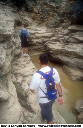
You may encounter pockets of standing water in the Devils Canyon slot but you can easily get around them with dry feet. It seldom rains in this area but the infrequent storms bring the potential for flash flooding so never enter this canyon during inclement weather. The narrow canyon was cut by powerful flash floods and you don't want to be caught in one.
Hiking 10 miles over obstacles may take up to 8 hours. Give yourself plenty of time, especially this time of year when days are short. Daytime temperatures will probably be mild but it gets cold as soon as the sun goes down. These narrow canyons are terribly dark at night, almost impassible even if you have a flashlight.
The Swell is a huge uplift in the earth's surface located between Price on the north and Hanksville on the south. It's steep slopes and rugged canyons made east west travel in that region virtually impossible until 1-70 was chiseled through its heart. The stretch of 1-70 across the Swell is very scenic and the drive provides a good introduction to the region.
 Devil's Canyon runs mostly parallel to 1-70, just a short distance to the south. It's located on the west side of the Swell. The old Copper Globe jeep road comes from 1-70 down into the canyon, to the starting point for our hike. To get on the Copper Globe Road exit at the Moore Cutoff (Exit 114) and take the frontage road that heads east, along the south side of the interstate. The paved frontage road follows the interstate for a short distance, then turns south, crosses a cattle guard and becomes the Copper Globe Road. It's a good gravel road for the first mile, down to Justensen Flats, then bumpy dirt down the side of the canyon. From the cattle guard along 1-70 to the bottom of the canyon is about 3.5 miles. The last mile is rough; to drive it you will need a high-clearance vehicle.
Several tracks lead from the main road to good campsites in the Justensen Flats area, and along the side of the canyon.
Park at the flat area just above the sand trap you’ll encounter where the road hits the bottom of the canyon. Start the hike by walking up the canyon to the east. You'll stay in the canyon bottom and go east for a couple miles, then southeast to the northeast side of the Knob.
Just follow the main canyon. You will pass tight narrows and move around potholes full of water. You'll encounter several small, dry waterfalls that you can climb over or scramble around. Finally you'll come to a large dry fall that is impossible to climb. You'll have to backtrack several hundred yards until you find a spot where you can scramble up the side of the canyon and get around the fall. Then back into the canyon.
Above the big fall the canyon forks. Go to the right (southeast) and follow the canyon until you can see the Knob. (Most people hike for about two hours to reach this point.) Exit the canyon and route-find to the base of the Knob.
There is an alternate, easier, route that will get you to the same place. From where you park, the old Copper Globe Road continues to the south, where it becomes a sandy and rugged track – virtually impassible to vehicles. Hike down the old road for about a half-mile and then look for a spur that climbs up to the top of the ridge.
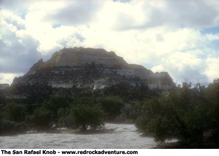
From the top of the ridge you should be able to see the Knob to the southeast – it’s the large, steep-sided monolith with a rugged top. The spur you are on forks several times on the ridge. One fork heads toward the Knob. Follow it or route-find to the base.
You can also ride horses to the base of the Knob — this is excellent riding country.
 It's best to approach the Knob from the northwest side. Climb the steep slopes and scramble over rocks until you reach the almost-vertical slickrock. Then make your way around to the south side and climb up to the top. It's not a difficult climb. Take your time.
(Warning: If there is any wind it will feel incredibly strong on top so be careful. If you hike during the cold season take gloves. You'll need to use your hands as you climb the Knob, and the rock will be cold. Your fingers will be numb by the time you reach the top.)
The top of the Knob is 7,921 feet above sea level – not very high compared to most Utah mountains. But it is the highest point in the Swell and you will think you're on top of the world. The view is marvelous, particularly on a day when there is little haze. Chimney Rock, Eagle Canyon, the Head of Sinbad, Temple Mountain – fascinating names that describe the wonderful areas spread before you.
From the top you can see how big – and rugged – the Swell is. The view whets you appetite and makes you want more. And there is plenty more, as you can easily see from the top.
Descend the Knob the way you came up. Get on one of several old road spurs and follow it west to the Copper Globe Road and then back to Devils Canyon and the parking area.
I made the hike on November 1, accompanied by two 13-year-old boys. These boys are strong hikers for their age but they had trouble scrambling over some of the dry falls. They were tired by the time we reached the Knob and chose not to attempt the summit. They really enjoyed the narrows in the canyon, but the entire hike was a bit much for them.
We hiked on a sunny, warm the day we hiked and the boys were reluctant to take jackets. But it was cool in shady areas in the canyon, and also cool when the breeze came up. It became quite cold as soon as the sun set. It's very important to dress in layers, so you can adjust for different conditions.
I love hiking during late fall and winter. As smog settles over the Wasatch Front and the temperature never climbs above 20 degrees, it’s great to drive out of the murk into the sunshine. Often temperatures are mild in southern Utah, even when it's bitterly cold along the Wasatch Front. The Swell provides a great escape.
It takes time and work to get to know theis area. The history is fascinating. Prehistoric Indians left rock art and cliff dwellings in many areas. For years traders herded horses and carried slaves along the Old Spanish Trail, which crossed the Swell. Wild horses still roam the hills, descendants of those that escaped the traders. More recently, cowboys and miners have left their marks on the land.
Copyright Dave Webb
