
Bike The Pony Express Trail
 Today,
as they did almost 150 years ago, young men load supplies into packs and
then climb onto the saddle to make a frantic dash across Utah's west desert.
Over 100 miles of rough dirt-trail then but now graded road-stretching
from Highway 36 on the east to Ibapah on the West, comprising perhaps
the loneliest, most desolate and challenging portion of the Pony Express
Trail.
Today,
as they did almost 150 years ago, young men load supplies into packs and
then climb onto the saddle to make a frantic dash across Utah's west desert.
Over 100 miles of rough dirt-trail then but now graded road-stretching
from Highway 36 on the east to Ibapah on the West, comprising perhaps
the loneliest, most desolate and challenging portion of the Pony Express
Trail.
They rode horses then, galloping between stations located at the few reliable water sources in the forbidding desert. Today they retrace the route using mountain bikes, a support vehicle with water, food and camping supplies following close behind.
The historic Pony Express Trail was also used by the Overland Stage and many immigrant groups heading to California. Today it's a route to high adventure for families and youth groups. Outings along the route can be customized to provide the degree of challenge appropriate for any particular group. Long treks are possible but so are short excursions around a base camp. There are plenty of places to stop and play along the trail. There's one developed campground and many areas that are wonderful for primitive camping.
Spring and fall are ideal times to camp along the trail. This open desert country is harsh during winter and summer, with frigid winter nights and boiling summer days. But the area gets little snowfall and winter days can be mild. From the comfort of a vehicle the area can be explored year-round. Biking is most enjoyable when daytime temperatures are cool- March, April, October and November are prime months.
The Pony Express began operation in April, 1860, to carry mail from St. Joseph, Missouri, the western end of the telegraphy line, to Sacramento, California. Riders galloped from station to station, then relayed the mail to the next rider who continued the trek. It took about eight days to cover the nearly 2,000-miles.
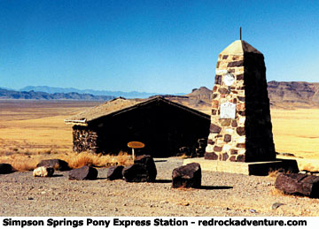
The ride across Utah's western desert was considered one of the most difficult legs of the route because of the harsh conditions, hostile Indians and long distances between stations. From Salt Lake City the trail headed south to Draper and then angled over to old Camp Floyd and Fairfield, then west past the tiny settlement of Faust and out into the desert. Mile after dusty mile they rode, over Lookout Pass to Simpson Springs, then up Dugway Pass and across to Fish Springs and Callao before skirting the Deep Creek Mountains, the Gold Hill area and then reaching the tiny settlement of Ibapah, on the Utah/Nevada border.
This article focuses on the first half of the route, from Faust to Fish Springs. The Deep Creek Mountains and Gold Hill areas deserve articles of their own.
Best places to camp
Simpson Springs: There is a developed campground here, with pit toilets. Water is available, but at this writing it was not considered suitable for drinking. There are several dirt roads around the campground that are fun for mountain bikers, dirt bikers and ATV riders. There is a fee to camp here.
Camping at the springs is on a first-come, first-served basis and getting a unit is seldom a problem. However, the campground often fills up during the deer hunt (mid October) and on Easter weekend.
Lookout Pass: There are several excellent primitive camping sites in the juniper trees just west of the Pass. These are large areas suitable for groups that want to get off by themselves. No facilities of any kind are available. There is no water. Old dirt roads around the pass offer excellent opportunity for mountain bikers and ATV riders.
Places to explore
Dugway Geode Beds: About six miles west of Dugway Pass a dirt road heads north into hilly country that contains numerous geodes. Genuine rock-shop-quality geodes can be found here. Some are hollow, others are completely filled with crystals. Agate, jasper and opal are commonly found inside these fascinating rocks. The variety is tremendous, both in terms of the size, color, and composition.
An old, fading sign marks the turnoff to the geode beds. The BLM controls the area and allows non-commercial digging with hand tools.
Fish Springs National Waterfowl Refuge: This is an excellent place to view wildlife. During the spring and fall the area attracts good numbers of ducks and geese. It is also home to a wide variety of other birds, including many that stay year-round. Hawks and eagles can often be seen soaring overhead. Coyotes and bobcats roam the marshland and cougars sometimes visit the area. Deer from a small herd live in the area year-round.
Mountain biking
The road follows the approximate route of the Pony Express Trail. The road becomes dirt beyond Highway 36, just west of Faust. In this area it is wide and smooth, with some sandy spots. The climb up over Lookout Pass is steep. From the pass the road continues past Simpson Springs and down into a valley where sandy spots become more frequent.
The best surface for fat tire riding is encountered when the road begins to climb Dugway Pass. The road narrows and the bed becomes firm. On both sides of this pass the road is steep and rocky, with many dips and turns. It's provides a fun ride.
Distances and elevation changes (lowest point to highest point) Highway 36 to Lookout Pass, 8.5 miles; 931 foot elevation change Lookout Pass to Simpson Springs: 16.5 miles; 1,500 foot elevation change Simpson Spring to Dugway Pass, 20 miles; 762 foot elevation change Dugway Pass to Fish Springs National Wildlife Refuge (east edge) 15 miles; 1020 foot elevation change
History
There's a lot of history in Utah's west desert. You can find ghost towns, old mines, abandoned railroad grades and relics from the stagecoach days.
In several spots you can see the ruins of old Pony Express stations, and historic markers show the locations of others that have been completely destroyed.
The Express began in 1860 when a San Francisco newspaper carried the notice: Wanted - young, skinny, wiry fellows not over 18. Must be expert riders, willing to risk death daily. Orphans preferred. Wages $25 a week.
From the beginning the owners poured thousands of dollars into the adventure and yet it only lasted 18 months, ending with the coming of the telegraph in 1861. William F. Cody, or Buffalo Bill, who tried about everything a frontiersman could try, was one of those young express riders.
A good place learn about the area's rich history is at Camp Floyd/Stagecoach Inn State Park, in Fairfield. Camp Floyd was established in 1858 when some 5,600 U.S. troops were sent to Utah to squash the supposed "Mormon Rebellion." Some 400 buildings were constructed there, housing what was then the largest concentration of troops in the country. When the Civil War broke out, the troops were shuffled east, but not in time to keep the Confederacy from winning impressive early victories.
Today a cemetery is all that remains of the camp.
The state park includes an inn that has been restored to period. The adobe building served as an overnight stop for the Pony Express and Overland Stage. It is open daily from Easter weekend through October 31.
Copyright Dave Webb