Cathedral Valley—A Great Bike Ride, A Remarkable Drive
By Dave Webb
 Michael
McCoy, author of Mountain Biking Adventures In The Four Corners Region,
describes the scenic loop through Cathedral Valley, in the northern part
of Capitol Reef National Park, as "the finest multi-day mountain bike
outing in the Milky Way Galaxy, if not the entire universe." With praises
like that, I decided it was time to get down there myself and see if it
deserves that kind of hype.
Michael
McCoy, author of Mountain Biking Adventures In The Four Corners Region,
describes the scenic loop through Cathedral Valley, in the northern part
of Capitol Reef National Park, as "the finest multi-day mountain bike
outing in the Milky Way Galaxy, if not the entire universe." With praises
like that, I decided it was time to get down there myself and see if it
deserves that kind of hype.
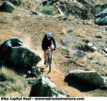
Michael's book is great–I recommend it. But, in this case I have to disagree with his conclusion. The ride is fun, and long (65 miles), and cuts through an amazing variety of scenic geological formations. It's up there near the top on my list, but there are several other rides in Utah that are as good or better. That said, this is a great ride that I highly recommend. It is also a fun area to explore via automobile. The loop follows a graded road that can be driven in a high clearance vehicle (four-wheel drive is not usually needed, but comes in handy in spots). The road crosses steep hill after steep hill, so it is a physically demanding ride. The road is sandy in many areas, and rocky in others, but this is not a technically difficult ride.
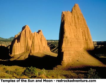
The scenery is remarkable, particularly if you are into photography, rock hounding or geology. You cross formations like the Bentonite Rainbow Hills, enchanted playgrounds that are almost impossible to pass without stopping to explore. You go by lookout points that offer breathtaking views of the Park's South Desert, the Waterpocket Fold, the Henry Mountains to the southeast, and Thousand Lake Mountain to the west. Cathedral Valley itself is spectacular, but it is almost upstaged by these supporting cast members.
 On
this loop there are long stretches of barren desert between the scenic
wonders. In my opinion, the loop is most enjoyable when explored as a
combination vehicle/bike trip. Drive the long stretches, then bring out
the bikes to play in fun spots, and to explore side trails. About half
of the loop is within Capitol Reef, the other half is on adjacent BLM
land. Vehicles (including bikes) are restricted to established roads inside
the park, but that still allows plenty of opportunity to play.
On
this loop there are long stretches of barren desert between the scenic
wonders. In my opinion, the loop is most enjoyable when explored as a
combination vehicle/bike trip. Drive the long stretches, then bring out
the bikes to play in fun spots, and to explore side trails. About half
of the loop is within Capitol Reef, the other half is on adjacent BLM
land. Vehicles (including bikes) are restricted to established roads inside
the park, but that still allows plenty of opportunity to play.
People who want to ride the entire loop, and want to spend a little time playing, need to plan for a multi-day trip. If you do a combination vehicle/bike outing, it will take at least two days to explore the area. It's possible to have an enjoyable outing, including a little exploration, in one full day, but you will only have time to see the highlights. If you just want to drive straight through, it takes most of a half-day to make the loop.
The Bentonite Hills are covered by clay, which becomes very gooey when wet. When the clay is wet it is almost impossible to drive or ride the roads. Even walking becomes difficult. The area is arid–it receives very little rain and even less snow, so it is usually accessible year-round. But don't venture in if rain is expected. If you have any question, check current conditions by stopping at the information desk in the visitor center at Capitol Reef.
Spring and fall are the best seasons to explore the area. Days are often mild during winter, and hiking or biking can be enjoyable at those times, but winter nights are usually downright cold. Temperatures sometimes climb up to 100 on summer days.
Regardless of when you go, carry plenty of water and emergency supplies. There is no drinkable water along the route. The loop is becoming more popular, but many days you will not see any other people. Be sure to carry tools to make basic bike repairs.
Most people choose to begin the loop at the Fremont River ford, just east of the park along Highway 24. The ford is usually not a problem for high clearance vehicles, but it can become treacherous during spring runoff or when flash floods come down the river. Check at the visitor center for current conditions.
Alternate Route
An enjoyable alternate route starts on Thousand Lake Mountain and ends at the river ford, or at Caineville. The road drops 3,000 vertical feet between Pole Creek on the mountain and Upper Cathedral Valley. It's mostly a straight shot down, which makes for an exciting bike ride. Be sure you have good brakes on your bike or vehicle before attempting this route.
I recommend you get the publication, "The Valley of Cathedrals," published by the Capitol Reef History Association. It is an excellent guide, one of the best I've seen. It was available for sale at the visitor center the last time I stopped in there. It describes the routes and attractions, which are identified by markers along the way. People who have an interest in geology will really enjoy this guide. It provides a well-written introduction to the geology of the area and I found it interesting reading.
Rock Hounding
Rockhounds will be tempted to scoop up buckets full of rocks along the route. Collecting is allowed on BLM land, but is prohibited inside the park. The Brushy Basin shale that makes up the Bentonite Hills was laid down during the Jurassic period and contains fossils in some areas. Some dinosaur fossils have been found in this formation. If you stumble onto a dinosaur fossil, remember the law requires you to leave it where you found it. On BLM land you can collect invertebrate fossils but not those from vertebrate animals.
Sharp-edged pieces of chert litter hillsides. Large gypsum crystals stick up through the clay.
There is a large sinkhole just off the route where gypsum has dissolved out of the underlying formation, causing the earth’s surface to collapse. For years it was thought that the pit was created by a meteorite smashing into the earth, but study has proved that theory wrong. The sinkhole is a dangerous area that has not been explored extensively. Because the sinkhole is hazardous, people are not allowed to explore there without written permission from the National Park Service.
Another interesting spot is Glass Mountain, where gypsum crystals glitter everywhere. Gypsum is common in the area, but the crystals here are particularly large. Since the mountain is within the park boundaries, collecting is forbidden.
You can easily collect oyster shell fossils from a spot along Highway 12, just west of Caineville. From the Fremont River bridge two miles west of Caineville, drive east for a half mile and park alongside the road. Walk north to the base of the hill and start looking. The fossils are numerous there.
Good deposits of collectible red and yellow agate can found on the side of Factory Butte, a short distance NE of Caineville. Follow the spur out of Caineville Wash for 2.2 miles, then turn right onto a Jeep trail and follow it for about seven miles. You will come to an old uranium mine. Park there and hike west to the head of a canyon, about .5 miles. Agates are found in the greenish gray clay in this area.
This is an area to enjoy. I could spend days exploring here.
Copyright Dave Webb