See our Nine Mile Canyon Photo Gallery.
Nine Mile Canyon is a phenomenal outdoor museum of ancient Fremont Indian rock art and structures, sprinkled with fascinating relics from Utah's pioneer era. The canyon boasts hundred of panels of rock art, many containing dozens of individual figures. The canyon is perhaps the best place on earth to view Fremont Indian petroglyphs and pictographs. (Petroglyphs are designs cut into the rock; pictographs are painted onto the rock. Both are represented in the canyon. In some places the ancient artists cut designs into the rock, then painted the designs — pictographs on top of petroglyphs.)
Much of the rock art can be viewed from the gravel road, which is graded and suitable for family car. Many others can be viewed from the road using binoculars. The canyon makes a great destination faor people who just want an enjoyable drive. But it is much more fun and rewarding to tour the canyon on a mountain bike.
 Some enthusiasts think you are not really mountain biking unless you charge headlong down a steep trail, dodging boulders and trees. I certainly understand the appeal of such a ride. But on this trip I enjoyed the easy, downhill glide.
I think a bike is the ideal means of transportation in the canyon. You can see more of the canyon, more easily, from a bike than you can from a car. You can travel slowly, giving yourself plenty of time to look around. There are no windows or frames to obstruct your view. And, if you want to head off onto a trail or side road, you just shift into low and start peddling.
Nine Mile allows visitors to enjoy the canyon and its treasures at their own pace. Stay in the car and peer out the window, park the car and hike to key spots, bike the canyon and its side roads and trails, or backpack. There is plenty of opportunity to get off the beaten path and see things which few others ever see, if you are so inclined. (Some of the trails and old roads in the area do offer exciting mountain biking opportunities, if you are looking for thrills.)
The name Nine Mile Canyon is deceptive. The canyon is actually about 40 miles long. Apparently the name originated when John Wesley Powell was leading a government expedition through the area in 1869. His topographer did a nine-mile triangulation drawing at a place he called Nine Mile Creek. The canyon was subsequently named after the creek.
 Most of the ancient sites in the canyon are on BLM land, with open access. You can walk right up — no rangers or marked walkways or chains to control the movement of visitors. Please respect these ancient sites so they can be enjoyed for years into the future. Don't touch the artwork — don't even run your fingers over them. Many have been vandalized — modern names and dates have been carved over some of the most impressive panels. Most of the vandalize occurred years ago, before the significance and of the sites was generally recognized, and before people recognized their fragile nature. But, sadly, more vandalism occurs every year. If we are not careful, if we don't respect the sites, they will be locked up and the public will not be allowed to enjoy them.
A considerable amount of land in the canyon is private property and some is posted "No Trespassing." Respect the private land, or more will be lost to public access.
The Fremont culture blossomed in the canyon beginning in about 300 A.D. The culture overlapped that of the Anasazi, located a bit further south, and apparently there was considerable contact between the two cultures. The Fremont culture is distinct, yet some aspects of the artwork, stone structures, pottery and basket work created by the Fremont people resembles that of the more famous Anasazi culture. To learn more about these people, visit Fremont Indian State Park, located SW of Richfield, in Clear Creek Canyon, along I-70.
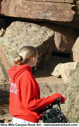
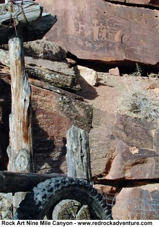
The Fremont were a hardy people who built dwellings of stone, wood and mud, some in the form of pit houses, along with stone granaries. Some well preserved examples of these structures can be viewed in Nine Mile Canyon.
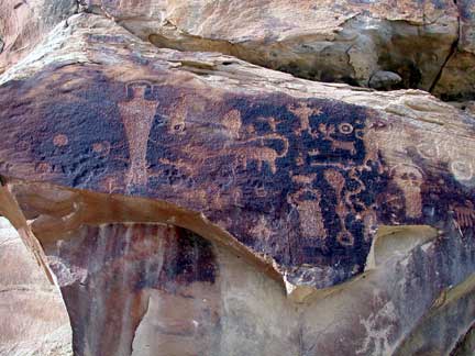
The rock art provides clues as to the daily lives of these people. Human-like figures are depicted in many panels, sometimes with horns, necklaces, earrings, shields and headdresses. The animals that were an important part of their world are often depicted. It is easy to recognize mountain goats, deer and snakes. Other figures are more difficult to identify.
 Scientists are making strides in deciphering what the art work might have meant to the artists of the day, but in many cases it is still unclear what the figures represent. Perhaps some were decorative, others seem to depict religious symbols and still others may tell stories which were significant to the people. Whatever the meaning, modern man finds them fascinating and beautiful.
It takes about 2.5 hours to drive from Salt Lake City to the top of Nine Mile Canyon. Most people who causally tour the canyon spend about six hours there. It's possible to make it a day outing from Salt Lake, but much more enjoyable to do it as an overnighter, staying in a motel in Price (or an outlying town), or camping out. Make sure you have plenty of fuel and supplies; there is nothing available after you leave Wellington. There are no designated camping areas in the canyon, but there are a few places that are suitable for primitive camping. Don't camp next to a major site because that would inhabit others from viewing the site. Don't build fire rings or do other things which will deface the land. If you camp, leave no trace!
Some of the prominent sites in the canyon are described below. The mileage reference describes the distance to the site from the end of the pavement, at Soldier Creek Mine. Odometer measurements vary from vehicle to vehicle, and so will not be exact. Some of the mileage measurements and descriptions are my own, others are based on a brochure published by the Castle Country Travel Region (P.O. Box 1037, Price, UT 84501). My measurements differed from those in the brochure for a few sites, and I checked carefully to make them as accurate as possible. Still, I did not have time to confirm measurements for every site, so don't bet you life on them. Some sites are easy to locate, some are quite difficult. There are countless sites which are not described anywhere. Part of the fun of such a canyon is exploring. . . searching. . . perhaps finding something that hasn't been seen for 1,000 years. Have fun!
To get into the canyon, travel east from Price on Highway 6, through Wellington, then look for the Soldier Creek Road, located on the east side of Wellington, adjacent to the Walker's Chevron station. A sign along the highway identifies the road as providing access to Nine Mile Canyon.
Drive north on the Soldier Creek Road for 12.9 miles to the Soldier Creek mine, and the end of the pavement. Start counting miles here, if you intend to use my mileage references.
Site #1: From the end of the pavement it is 13.7 miles to the first major rock art panels, which are on a rocky ridge which extends almost right up to the road. The ridge is easy to identify because someone has chipped large letters "SSC" into the rock adjacent to the road. Look for ancient figures on several of the smooth, dark, vertical rock panels along the ridge, near the road. People who are not use to seeing rock art may have a difficult time recognizing them at first, but many are quite obvious if you study the panels. In most cases the dark patina has been chipped away, creating the design by exposing the lighter rock. Some of the artwork is faded and harder to see; some of the figures have modern names and dates carved over them.
Site #2: 17 miles from the pavement. If you look hard (and you're lucky) using binoculars you can see the remains of a rounded Fremont structure. It is located on a sagebrush-covered hill to the left of the road. On top the hill is a flat-topped rock. Below the rock and to the left is a cliff with several long cracks. The structure is near the base of the cracks. Several pit houses are located on the lower ridge to the right.
Site #3: At 18 miles you will come to the ghost town of Harper. It was once a stage coach stop and sheep ranch.
Site #4: 19.55 miles from the pavement you will come to a large panel with a variety of petroglyphs that are well preserved. The rocks on both sides of the main panel also have carvings. The site is located on the left side of the road, just past a balanced rock near the left edge of the road. The balanced rock somewhat resembles Porky Pig.
Site #5: 20.9 miles. There are many figures all along this section of canyon, in the black patina halfway up the cliff face to the left of the road. One large panel includes several human shapes, some with Readdresses, toes and fingers. Also look for deer. Notice the square designs created by chiseling dots into the rock.
Site #6: 22.3 miles. A large panel here includes some unique and interesting figures. The panel is easy to locate because it features a large snake which stands out distinctly. Look for trees, birds and human figures with hands and feet. The panel is located to the left of the road, halfway up the hillside. Park alongside a clump of cottonwood trees, located in the field on the right side of the road.
Site #7: 25.8 miles. The remains of a granary are located on the hillside here. The front has been washed away, but the floor, ceiling and walls are visible.
Site #8: 26.8 miles. A well-preserved granary is located above a ledge on the left side of the road.
Site #9: 30.8 miles: Rassmussuen's Cave. There are many excellent pictographs in this area.
Site #10: 31.8 miles: Cottonwood Canyon Road forks to the right. It leads to some interesting sites. The Nine Mile Canyon Road continues to the left, also leading to many more sites.
Site #11: 1.2 miles up the Cottonwood Canyon Road you will find a panel which shows a splendid hunting scene. It is located to the right of the road.
There's plenty more in the canyon, if you hunt it out.