(UTAH FISHING & OUTDOORS - December 1, 1991)
If you're an avid hiker, there’s no need to give up your passion during the winter months. There are plenty of places to hike even if the mountains are snowed in. We’ll be bringing you some winter hiking suggestions in future columns in this magazine.
But this issue’s column is dedicated to helping you plan ahead for one of Utah’s biggest and most demanding hikes — the hike to Kings Peak, the highest point in Utah. This is a hike that you just don’t run out and do without any preparation. It takes planning and coordination and if you want to do it next summer, it’s best to start thinking about it now.
So the purpose of this column is to get you excited and get you thinking about making the trek. Later in the spring I'll write a column on specific preparations for Kings Peak.
I've hiked to the top of Kings Peak three times now, and each time has been a bigger thrill than the last. It's especially fun to take someone to the top who hasn’t been there before and watch the joy and wonder unfold before them. The scenery is indescribable and you just can’t duplicate the feeling of being deep in the wilderness and high above timberline.
You also can‘t beat the satisfaction and fulfillment of conquering the mountain, of hiking 32 to 40 miles (depending on the route) round trip to the 13,528 level and back.
No one should attempt the Kings Peak hike if they’re out of shape and overweight. You wouldn't go out and run a marathon without serious training. The Kings Peak hike is almost as tough. A regime of walking and/or jogging is very necessary to build up the lungs and muscles, especially because you can’t hike Kings Peak in one day, so you have to carry a loaded backpack in at least part way to a base camp (unless you use horses or an outfitter).
Therefore, any plan to hike Kings Peak ought to include some serious exercise beforehand. The exercise plan should include a fair amount of walking up steep hills or stairs. You can‘t duplicate a hike to the 13,528- foot level without some uphill walking.
However, the difficulty of the hike shouldn't prevent anyone in reasonably good health from trying it. I met a couple in their 70s at the top of Kings Peak and youngsters as young as 8 do remarkably well. The key is getting into shape and then taking the hike at a comfortable pace. No one needs to race to the top. The point is to get there and enjoy the hike along the way. The closest access point to Kings Peak is the Henry‘s Fork trailhead on the North Slope of the Uintas, about a three-hour drive from Salt Lake City. You get to the trailhead via Evanston, Fort Bridger and Mountain View. It’s about a 20-mile drive on dirt roads from Mountain View to the trailhead.
The hike from the trailhead to base camp is a beautiful trek along the Henry’s Fork River. For the first several miles you are in thick pine forests with periodic meadows. The incline is fairly gradual except for a few spots. Eventually, you emerge from the forests into a broad valley, dotted with lakes and timber stands, surrounded on almost every side by steep, rocky, above timberline peaks, the highest peaks in Utah. The scenery is breathtaking and you can see for miles.
 The best spots for base camp are either Dollar Lake or Henry’s Fork Lake. You can do the entire Kings Peak trip in three days, figuring one day’s hike to base camp, the next day up to the peak and back, and the third day to hike out. But that will require some hard hiking and you won‘t have much time to fish or relax. It’s better to figure on four or five days to enjoy the experience to the fullest. Henry’s Fork River, from the bottom to the top, is full of fish, including some 14-inch cutthroats, and the numerous lakes have lots of cutthroat and brook trout. Dollar Lake gets fished quite heavily, but some of the others, especially Cliff Lake and Castle Lake, get very little pressure.
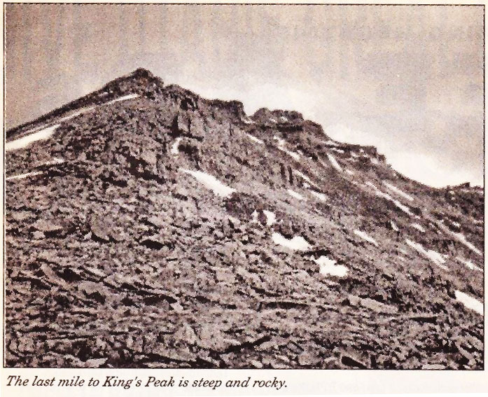
Good maps and map-reading skills are important, of course. With the right topographic maps, available at USGS offices and some other locations, you can see exactly where you are at all times. From base camp at one of the lakes in the area, you can choose from two routes to Kings Peak. The recommended way is up over Gunsight Pass (11,888 feet), down into Painter Basin and then up to Anderson Pass (12,800 feet) before the final mile-long ascent up the boulders to Kings Peak.
The other route is much more direct, up the “chute" -— a steep, rock-strewn rock slide that is shorter but much more difficult than the traditional route. At Anderson Pass, you still must ascend 900 vertical feet and there is no trail, just a scramble of a mile or so up boulders and rocks. On one side is a steep drop off of 1,000 feet or more. On the top, you’ll have a view of major high Uinta basins in all directions, You‘ll see dozens of lakes and peaks as the clouds swirl around you. So if you're interested in the Kings Peak hike, now is the time to start planning and thinking about it. Obtain some good maps and start plotting your course. In future issues we‘ll provide more details and information about the hike, including a great recipe for trail mix that will keep you going even if you run out of all other food.
On the Kings Peak hike you'll likely see deer, elk, moose and other wildlife. We saw more than a dozen moose on our last trip. You‘ll also enjoy the pikas — the small, furry, guinea pig-like animals that whistle at you from the talus slopes above timberline.