By Dave Webb
April, 2023
Below we list our favorite backpacking trails. Many others could go on the list. For example, many Wasatch Mountain trails are commonly done as day hikes but could be backpacks. We could fill many pages with just Uinta Mountain trails. Those listed below are our favorites.
Coyote Gulch
Distance varies depending on which trailheads you use, ranging from about 12 to 22 miles total. Located SE of Escalante, off Hole In The Rock Road. Permits are required for overnight stays but not for day use. Permits can be obtained at the visitor center in Escalante or at trailheads. Spring and fall are the best times to hike. This has become a popular hike so expect to see other people, especially when school is out for spring and fall breaks.
The scenery is Coyote is spectacular so bring a camera. The most scenic features are Jacob Hamblin Arch, Coyote Natural Bridge, and waterfalls in the lower canyon.
Coyote Gulch backpacking information.
Reflection Canyon Overlook
This is an 18-mile out-and-back route that route ends at a viewpoint above Lake Powell’s Reflection Canyon. The canyon’s sculpted red rock walls and contrasting deep blue waters make for a stunning photo that has become iconic.
The trailhead is located off Hole In The Rock Road. The area is remote and rugged. It is an adventure just getting to the trailhead. The route is not well defined and this is only recommended for strong hikers with good backcountry navigation skills. There is no water along the entire route – you must carry all that you will need. The route has full sun exposure and summer temps are very hot. Spring and fall are the best times to hike.
Reflection Canyon backpacking information.
Golden Cathedral
The route we recommend is about 9 miles round trip, off Hole In The Rock Road. The trail is not steep or particularly rugged and can be done as a day hike, but is more enjoyable as a backpack. The cathedral is a very scenic alcove off the Escalante River containing an iconic triple pothole arch. You will be wading the river, and the water is cold even in the summer, but much of the trail has full sun exposure. Spring and fall are the best hiking seasons here. The website has a good description.
Canyoneers with technical skills and equipment enter Neon Canyon above the cathedral and rappel down the arch. That is a wonderful adventure but beyond the scope of this article.
Death Hollow
This is a long, fun, challenging backpack through a beautiful water-filled slot canyon. The length and difficulty vary depending on the exact route you choose. We recommend a 3-day, 2-night loop that covers about 25 miles.
-
8 miles from Escalante River Trailhead along the Old Boulder Mail Trail to Death Hollow
-
9 miles down Death Hollow to the Escalante River
-
5 miles up the Escalante River to town trailhead
-
An alternate endpoint would be the Highway 12 bridge over the Escalante River. This option would require a vehicle shuttle.
An alternate route starts at the very top of Death Hollow, along Hells Backbone Road, and requires canyoneering skills and equipment to descend the canyon.
It is also possible to hike up or down the Escalante River to the confluence of Death Hollow, then up Death Hollow to explore the lower end, then return the way you came.
This area is part of the Box Death Hollow Wilderness and so take care and obey the rules. A permit is needed for overnight stays. You can camp pretty much anywhere. The first part of our recommended loop is usually dry and so you need to carry water. The lower portion has running water and you will be wading.
Boulder Mail Trail
This is a classic route through canyon country that cuts across slickrock, wide open spaces, narrow canyons and small streams. The trail runs for about 15 miles, from Escalante up to the Boulder area. Some do it as a long day hike but it is better as an overnight backpack. A vehicle shuttle is required. Here is a good overview.
Most of the route is dry and has sun exposure. Carry plenty of water.
This rugged area was the last part of the continental US to be surveyed and mapped. From 1902 until Hwy 12 was paved in 1940, the US mail to Boulder was delivered using pack horse and mule via the old trail. After 12 was paved, the trail fell into disuse. In recent years it has become a popular backpack route and it can be combined with spurs to create longer treks.
Boulder Mail Trail information.
Cosmic Ashtray
The Cosmic Ashtray is a strange, interesting, and photogenic feature in Grand Staircase Escalante National Monument, off Hole in the Rock Road. It is a large, circular rock where the middle has eroded out and filled with orange sand.
Round trip distance is about 8.5 miles. Many people do it as a day hike. We include it as a backpack because we are into serious photography and photos of the formation are more impressive when shot early or late in the day. We recommend camping nearby and shooting during the magic hours.
There is no marked trail and good route-finding skills are needed. The hike is over open desert with full sun exposure. It is best done during spring and fall. Regardless of the season, carry more water than needed because you won’t find any along the route.
Cosmic Ashtray hiking information.
Halls Creek Narrows
This is a rugged 22.4-mile route that allows you to explore the southern portion of Capitol Reef National Park. You hike through a water-filled slot canyon on the lower portion of the route. Most people need three days, and two nights to complete the route.
The trailhead is the Halls Creek Overlook. It is located about 56 miles south of the Visitor Center at the end of a dirt road that requires high-clearance four-wheel drive. Getting to the trailhead is an adventure in and of itself. The scenery is spectacular.
From the overlook, you hike about 7.3 miles into the drainage to the start of the slot canyon. This portion has sun exposure and is very hot during summer.
You then loop through the slot before returning the way you came in. The slot is narrow and always contains water. Pool depth varies from year to year and season to season but there will be pools that require swimming, and the water is cold. The payoff is a fun slot that is beautiful and fun but not overly difficult.
Later spring and fall are the best times to hike. This site has Halls Creek Narrows backpacking information.
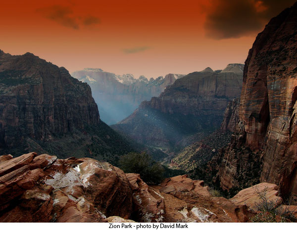
Zion West Rim Trail
Most people hike from Lava Point (Kolob Terrace Section) down the mountain to the Grotto in Zion Canyon (passing Scout Lookout and skirting Angels Landing). The route runs for about 16 miles and requires a shuttle. It can be done as a long day hike but is better as an overnight backpack. Permits are required and campsites are designated.
The hike provides views of some of Zion’s best scenery. It is a fun route that is not overly strenuous. The Lava Point area is snowed in until later spring. The best times for this route are spring (as soon as the snow is gone) and early fall. It can be hiked during summer since much of the route is at higher elevations with tree cover, and it is mostly downhill, but the lower end will be very hot.
It is possible to do loop day hikes up on the mountain that provides unique views of Zion from the top, never seen by most tourists.
Here’s West Rim backpacking information.
Zion Traverse
Also called the Trans-Zion, this is a group of connected trails that run for about 48.3 miles (with many options for spur trails). We recommend three or more days. Permits are required and are limited. A shuttle is required.
People hike east from Lee Pass (Kolob Canyons section) to the East Rim Trailhead or reverse to hike west. Doesn’t matter which you choose. There are significant ups and downs (elevation gain and loss), into and out of canyons, and stream crossings.
For many people, this is the adventure of a lifetime.
Here is information on the Zion Traverse.
Buckskin Gulch
We recommend the Wirepass to Whitehouse Trailhead, which is 21 miles and best done as an overnight backpack. Day hikers often go from Wirepass down to the confluence with Buckskin and then return the way they came, for 3.5 miles. Day hikers can go down Buckskin a ways to see more and make the hiker longer.
Buckskin is one of the longest slot canyons in the world and is very deep along much of its length. There are only a few places where you can get out of the canyon. There is usually water in the canyon. Depending on the time of year, there may be holes you must swim through. The water is cold.
This canyon has a high danger from flash floods. It drains an extensive area and so rain miles upstream may cause flooding. Since the canyon is so long and deep, there is often no way to get out if a flood comes. Use caution; check and weather and other conditions carefully before you go in.
Permits are required.
Many people consider this the ultimate canyon hike.
Buckskin Gulch backpacking information.
Dark Canyon
Dark Canyon is a large wilderness area located south of the Colorado River. It offers many options for hiking and backpacking, with some routes going 40 or more miles. It includes great geologic and ecologic diversity and outstanding scenery. It is a place where you can still find solitude if you work at it.
One popular route starts in an alpine forest at an elevation of 9000 feet and drops down into the desert following a small stream into twisting canyons. The area is home to black bears and mountain lions, but they are rarely seen by visitors. You will also pass an assortment of archaeological sites with ruins and still some pottery shards.
You need to do your homework before venturing into this wild area. It is an American treasure.
Here’s information on backpacking Dark Canyon.
Grand Gulch
Grand Gulch is one of the best places to view ruins and relics from the Ancestral Pueblo culture. It is a rugged wilderness area that has become very popular for backpacking and horse-packing treks. Permits are required and are limited to protect the environment and fragile ruins.
One popular route runs 20 miles from the Kane Gulch trailhead down into Grand Gulch and then up Bullet Canyon. Most people make this trek is 2-3 days and a shuttle is required. There are many other possible routes including some that run 60 or more miles. There are also options for day hiking.
The scenery is impressive but the ancient ruins are the primary attraction. They are amazing.
Here is Grand Gulch backpacking information.
Big Needles Loop
The Needles District in Canyonlands National Park is well known for rugged Jeep trails that test the mettle of man and machine. There are also many great hiking and backpacking trails in the area. We recommend the Big Needles Loop, which runs for 23.2 miles and exposes backpackers to many of the best features of this scenic area.
This is wild country with little water and harsh conditions. Summer days are hot and winter nights are bone-chilling cold. Spring and fall are the best times for extended hikes and backpack trips.
Permits are required and camping is regulated. Only a limited number of permits are available and competition is fierce for the coveted spring and fall slots.
Detailed information on the Big Needles Loop.
High Uintas
There are dozens of popular backpacking routes in the High Uinta Mountains, in NE Utah. Some trails, like Kings Peak and Grandaddy Lake, attract hoards of hikers. Most maintained trails receive more moderate use. It is still possible to find solitude at the more remote lakes and also at lakes off the trail. Fishing is a primary attraction and is good at most lakes.
This is the highest elevation area in Utah and winter snow piles deep. Most years, the high country becomes accessible in early or mid-July. This year, it may be late July or August before the high lakes open up. Snow may never melt completely from some of the highest passes.
Our website has many great articles on the Uinta Mountains. Some of our information is dated. Be sure to learn about current conditions to venturing out.
Boulder Mountain
Rough dirt roads crisscross the Boulder Mountain area. Most lakes can be reached by vehicle but some lakes with excellent scenery and great fishing can only be reached by hiking. It is possible to day hike to virtually all lakes that are not accessible by vehicle. However, the best fishing is early in the morning and late in the evening and so we often choose to camp where they fish.
This high mountain area usually opens up in early June, but it may be later this year. Always check current conditions.
See our excellent Boulder Mountain articles.