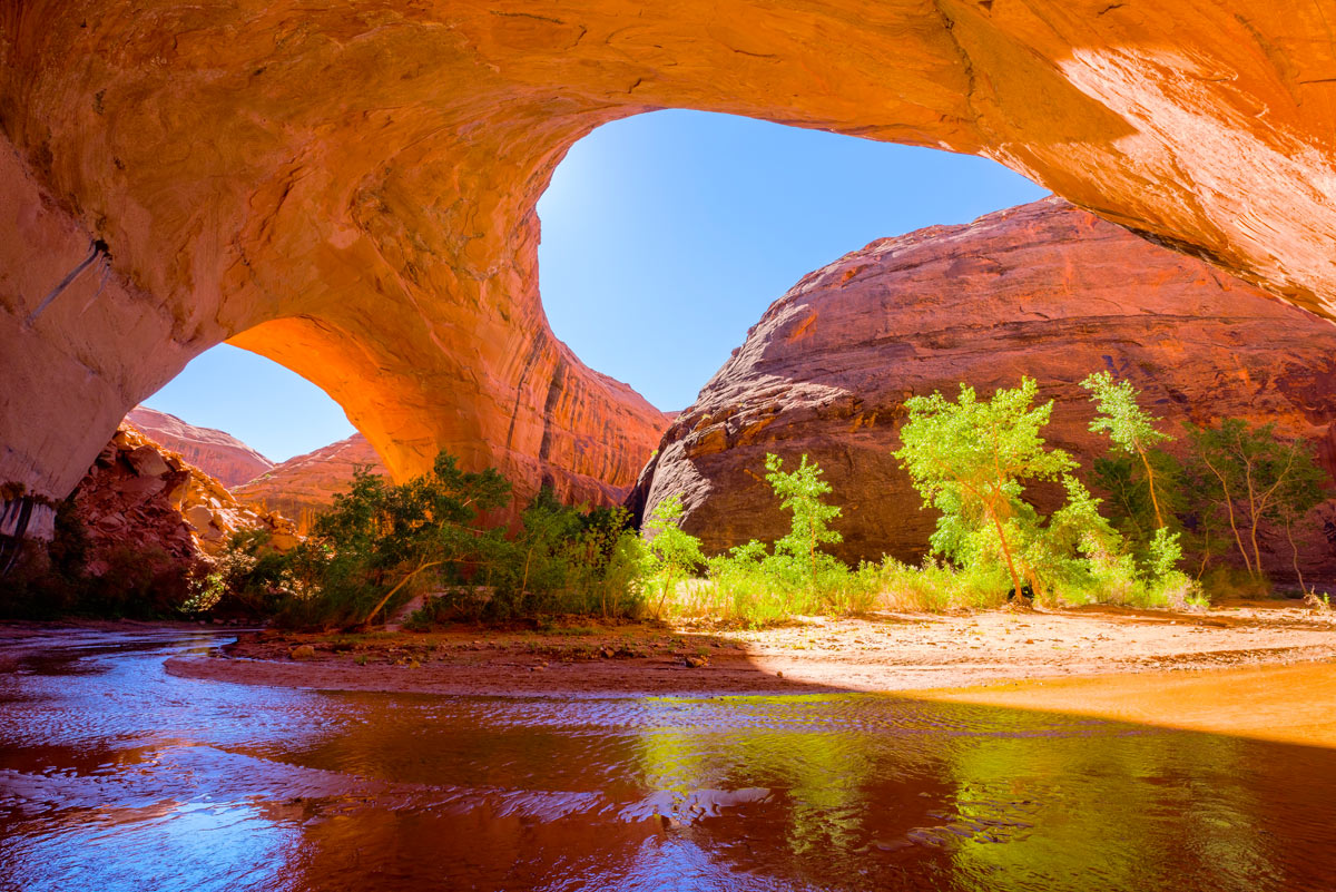
Jacob Hamblin Arch in Coyote Gulch
By Dave Webb
April 3, 2024
Coyote Gulch is a scenic canyon in southern Utah (Grand Staircase-Escalante) that has become very popular with hikers, backpackers, and photographers. It offers great opportunities for day hikes and is even better as a one or two-night backpack trip.
Many photos of features in the canyon have become iconic including Jacob Hamblin Arch and Coyote Natural Bridge, plus waterfalls and cascades showcasing the small stream trickling down redrock.
Exploring the canyon is a bucket-list trip. Hiking here is a significant undertaking that requires careful planning. Some routes are strenuous and the rough terrain brings inherent dangers.
Young artist and poet Everett Ruess described this area, and other SW landscapes, with immortal words:
“I have seen almost more beauty than I can bear.”
“I'll never stop wandering. And when the time comes to die, I'll find the wildest, loneliest, most desolate spot there is.”
Ruess wandered south from the town of Escalante, down the Hole In the Rock trail, and disappeared into the desert. His camp and burros were found in nearby Davis Gulch. His body has never been found and his death remains a mystery – part of the lore of canyon country.
Coyote Gulch Overview
In the past, people came to Coyote Gulch to find solitude in a beautiful desert setting. With the popularity of the canyon, you will not find solitude here. Expect to see other hikes/backpackers. But the beauty of the canyon has not changed and it remains a major draw.
Jacob Hamblin Arch, Coyote Natural Bridge, and Swiss Cheese Waterfall are amazingly photogenic and are primary attractions.
The entire route is scenic.
Dangers
This is a harsh, remote area. In summer, daytime temperatures can get very hot (100+ F). In winter, nighttime temperatures can be bitter cold (0 F). People can safely hike/backpack the canyon year-round if they have appropriate gear. April/May and later September through mid-November offer the most pleasant temperatures.
Flash floods are a real danger. Always watch the weather. Floods are most common in August but can happen anytime.
Stream water must be filtered and/or treated to be safe to drink. A reliable stream flows through the popular sections of the canyon and there are several springs. Even at springs, water should be treated.
The hike includes many stream crossings and sometimes you must walk in the stream. Your feet will get wet. In most places, the water is only ankle-deep.
Coyote Gulch Location and Access
Coyote Gulch is a tributary to the Escalante River north of Glen Canyon. Access is via the Hole In the Rock Road. The route is dirt/sand and its drivability varies depending on recent weather conditions. During dry weather a crossover vehicle can usually make it to three of the four trailheads. During wet/stormy weather it may be undrivable even with high-clearance four-wheel-rive.
Check this road report updated by the National Park Service: https://www.nps.gov/glca/learn/news/road-conditions.htm. Better yet, call the Escalante Interagency Visitor Center, 435-826-5499, to get current information.
The Hole In The Rock route was blazed by settlers who showed incredible perseverance and ingenuity as they blasted and chiseled a wagon road through some of earth’s most rugged landscapes. Learn about their journey: https://ensignpeakfoundation.org/hole-in-the-rock-expedition/
Hole In The Rock Road begins six miles east of the town of Escalante, off Hwy 12. It is signed and easy to find.
• The road is about 270 miles south of Salt Lake City. It usually takes 4.5 to 5 hours to drive to the beginning of the road from the SLC airport.
• It is about 300 miles from Las Vegas to the start of the road (about 4:45-5 hours).
Trip Length
The minimum hiking distance to see Jacob Hamblin Arch and Coyote Natural Bridge is about six-plus miles (roundtrip). Most people want to wander and explore and so a reasonable length is eight or more miles. If you backpack from Hurricane Wash or Red Tank you need to expect to do 20 or more miles.
Many people enjoy day hiking here. If you are staying in Escalante it is a long day trip driving to a trailhead, hiking in and out, then returning to Escalante. Hole in the Rock Road is bumpy with washboards so travel is slow. Plan on a 10-plus hour day. A better option is to camp somewhere nearby.
If you want to see much of the canyon you need to plan a two-day, one-night backpack, and if you really want to explore then plan on three days, and two nights in the canyon.
Trailheads And Routes
Four main trailheads lead into Coyote Gulch. The first three are usually accessible without the need for high-clearance four-wheel drive. Reaching the Crack in the Wall Trailhead requires driving through deep sand and high-clearance is needed.
Red Well: 37.429919, -111.146468
Drive Hole-in-the-Rock road 30 miles to the signed junction, then turn east and drive 1.5 miles to the trailhead. From the trailhead, you can hike down Coyote Gulch for 13 miles to the Escalante River. The first mile will be dry and then you will pick up the perennial stream. It will start small and the water flow will increase as you go down-canyon. The first half of this route is not particularly scenic.
Hurricane Wash: 37.385851, -111.132355
Follow the Hole-in-the-Rock road 33 miles to the parking area beside the road. The trailhead is located across the road. From the trailhead, you can hike down canyon for 12.3 miles to the Escalante River. The first 3.5 miles of the hike will be dry and not particularly scenic.
Water Tank (Sneaker): 37.392645, -111.048552
Drive Hole-in-the-Rock road 35 miles to the signed junction, then turn east and drive 4 miles to the trailhead. This trailhead provides the shortest route into the scenic part of Coyote Gulch.
Crack in the Wall: 37.403584, -111.008969
Follow Hole-in-the-Rock road 35 miles to the signed junction, then turn east and drive 7 miles to the trailhead. (Crack in the Wall is three miles past Water Tank, on the same road.)
The elevation at the Water Tank Trailhead is 4,810 feet. The elevation at in the canyon bottom near Jacob Hamblin Arch is about 4625 feet.
Recommended Route From Water Tank (Sneaker) Trailhead
I recommend this because most vehicles can reach the trailhead and it offers a short, direct route into the most scenic part of the canyon but it requires descending a steep canyon wall (rated as a “class 5” friction scramble). To get down, many people sit down in spots and slide along the rough sandstone. Some people appreciate holding a rope for security as they descend. This might not be the best trailhead for people afraid of heights, but it really isn’t that bad if you just take it slow and use caution.
From the trailhead parking, hike north to the canyon rim. At first, you’ll be hiking across sand and the trail will be obvious. Soon you will come to slickrock where the trail may not be obvious. You will do fine if you just hike north and watch for cairns.
As you approach the rim you will be able to see the opposite wall of the canyon. Look for a white, U-shaped mark on that wall (some refer to it as a bird shape). Hike toward it and look for cairns marking the best spot to descend into the canyon.
When you reach the canyon floor you can explore up and down stream.
Jacob Hamblin Arch (37.419574, -111.042617) will be a short distance upstream. If you continue hiking above Jacob Hamblin you will find a beautiful narrow canyon. The confluence of Hurricane Wash and Coyote Gulch is just over a mile above Jacob Hamblin. If you have the time and energy, I recommend going that far.
The canyon’s more famous attractions begin with Jacob Hamblin and continue downstream in this order:
Swiss Cheese Waterfall (37.415511, -111.033489)
Coyote Natural Bridge (37.416388, -111.026743), about 1.5 miles downstream from Jacob Hamblin Arch. If you search nearby you can find Fremont Indian rock art and a small ruin in an alcove.
Black Lagoon Spring & Pool (37.417641, -111.021217)
Cliff Arch (37.419816, -111.007184)
Escalante River (37.427962, -110.980920)
Stevens Arch (37.433504, -110.979525)
Hike/backpack as far as you have time and energy and then return the way you came in.
Crack In The Wall/Water Tank Loop
If you have two vehicles you can do a loop between the trailheads on Forty Mile Ridge. I recommend starting at Crack In The Wall and exiting to the Water Tank Trailhead. From the Crack In The Wall Trailhead, you hike northeast for 1.9 miles to the crack feature. Squeeze through it and continue another mile down a large sand dune to the bottom of the canyon. You will be just above the confluence of Coyote Gulch and the Escalante River and most of the canyon’s attractions will be upstream.
I recommend doing the loop in this direction because it is easier to hike down rather than up the dune. Going up can be grueling, particularly if you have hot sun.
Rules And Regulations
Always check the NPS Coyote Gulch page for the latest rules and information: https://www.nps.gov/glca/planyourvisit/coyote-gulch.htm
Permits are required for overnight stays and can be obtained at the Escalante Interagency Visitor Center or at trailheads.
Permits are not required for day hikes. Day hikers should sign the register at trailheads.
Group size limit is 12 people.
Carry out all human waste solids, toilet paper, and hygiene products. This is from the rules page: “All human body waste solids shall be contained and carried out using a portable toilet or a specifically engineered bag waste containment system in Coyote Gulch.” Regular zipping bags aren’t sufficient. You must carry and use a specifically engineered bag waste containment system containing enzymes and polymers to treat human waste. The bags must be capable of being sealed securely.
Fires are not permitted in Coyote Gulch.
Do not build cairns.
This map locates the Water Tanks (Sneaker Route) Trailhead.